You are here: Home > Network List > TA - USArray Transportable Network (new EarthScope stations) Stations List
> Station I30M Mount Dempster, Yukon, CAN > Earthquake Result Viewer
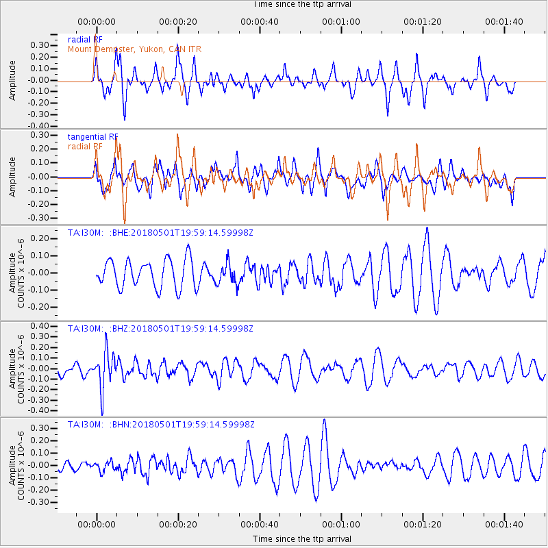
I30M Mount Dempster, Yukon, CAN - Earthquake Result Viewer
*The percent match for this event was below the threshold and hence no stack was calculated.
| Earthquake location: |
Fiji Islands Region |
| Earthquake latitude/longitude: |
-18.0/-178.0 |
| Earthquake time(UTC): |
2018/05/01 (121) 19:47:53 GMT |
| Earthquake Depth: |
579 km |
| Earthquake Magnitude: |
5.9 Mww |
| Earthquake Catalog/Contributor: |
NEIC PDE/us |
|
| Network: |
TA USArray Transportable Network (new EarthScope stations) |
| Station: |
I30M Mount Dempster, Yukon, CAN |
| Lat/Lon: |
65.22 N/136.38 W |
| Elevation: |
1399 m |
|
| Distance: |
88.8 deg |
| Az: |
16.251 deg |
| Baz: |
219.197 deg |
| Ray Param: |
$rayparam |
*The percent match for this event was below the threshold and hence was not used in the summary stack. |
|
| Radial Match: |
60.914177 % |
| Radial Bump: |
348 |
| Transverse Match: |
44.184826 % |
| Transverse Bump: |
396 |
| SOD ConfigId: |
13570011 |
| Insert Time: |
2019-04-30 04:26:24.304 +0000 |
| GWidth: |
2.5 |
| Max Bumps: |
400 |
| Tol: |
0.001 |
|
Signal To Noise
| Channel | StoN | STA | LTA |
| TA:I30M: :BHZ:20180501T19:59:14.59998Z | 2.7920127 | 1.7862065E-7 | 6.397559E-8 |
| TA:I30M: :BHN:20180501T19:59:14.59998Z | 0.7159652 | 3.785726E-8 | 5.2875833E-8 |
| TA:I30M: :BHE:20180501T19:59:14.59998Z | 0.7596192 | 6.16989E-8 | 8.122346E-8 |
| Arrivals |
| Ps | |
| PpPs | |
| PsPs/PpSs | |


