You are here: Home > Network List > TA - USArray Transportable Network (new EarthScope stations) Stations List
> Station J26L Joseph Creek, AK, USA > Earthquake Result Viewer
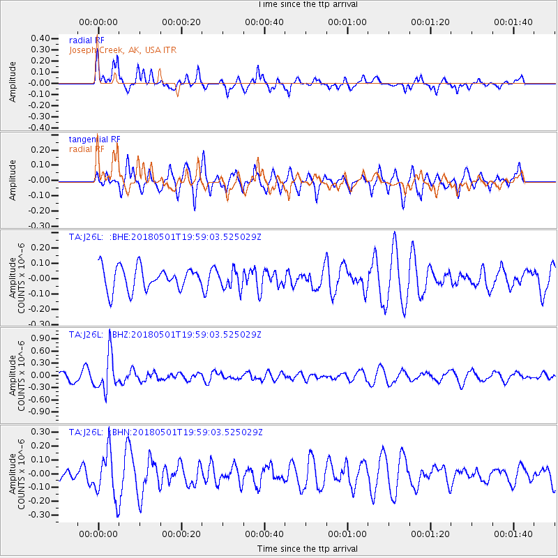
J26L Joseph Creek, AK, USA - Earthquake Result Viewer
*The percent match for this event was below the threshold and hence no stack was calculated.
| Earthquake location: |
Fiji Islands Region |
| Earthquake latitude/longitude: |
-18.0/-178.0 |
| Earthquake time(UTC): |
2018/05/01 (121) 19:47:53 GMT |
| Earthquake Depth: |
579 km |
| Earthquake Magnitude: |
5.9 Mww |
| Earthquake Catalog/Contributor: |
NEIC PDE/us |
|
| Network: |
TA USArray Transportable Network (new EarthScope stations) |
| Station: |
J26L Joseph Creek, AK, USA |
| Lat/Lon: |
64.50 N/143.56 W |
| Elevation: |
1144 m |
|
| Distance: |
86.4 deg |
| Az: |
14.188 deg |
| Baz: |
212.61 deg |
| Ray Param: |
$rayparam |
*The percent match for this event was below the threshold and hence was not used in the summary stack. |
|
| Radial Match: |
58.46769 % |
| Radial Bump: |
357 |
| Transverse Match: |
59.025654 % |
| Transverse Bump: |
400 |
| SOD ConfigId: |
13570011 |
| Insert Time: |
2019-04-30 04:26:28.434 +0000 |
| GWidth: |
2.5 |
| Max Bumps: |
400 |
| Tol: |
0.001 |
|
Signal To Noise
| Channel | StoN | STA | LTA |
| TA:J26L: :BHZ:20180501T19:59:03.525029Z | 4.4280562 | 4.4699414E-7 | 1.00945904E-7 |
| TA:J26L: :BHN:20180501T19:59:03.525029Z | 2.594229 | 1.7367235E-7 | 6.694565E-8 |
| TA:J26L: :BHE:20180501T19:59:03.525029Z | 0.8535208 | 6.307255E-8 | 7.3896906E-8 |
| Arrivals |
| Ps | |
| PpPs | |
| PsPs/PpSs | |


