You are here: Home > Network List > TA - USArray Transportable Network (new EarthScope stations) Stations List
> Station I30M Mount Dempster, Yukon, CAN > Earthquake Result Viewer
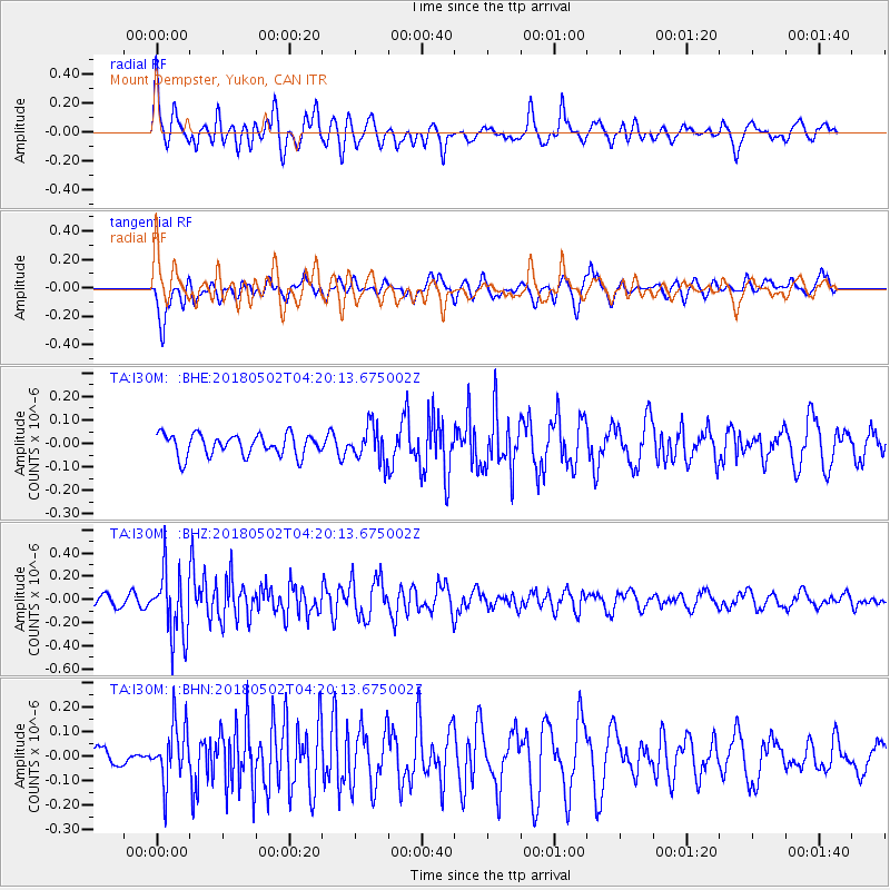
I30M Mount Dempster, Yukon, CAN - Earthquake Result Viewer
*The percent match for this event was below the threshold and hence no stack was calculated.
| Earthquake location: |
Northern And Central Iran |
| Earthquake latitude/longitude: |
30.7/51.5 |
| Earthquake time(UTC): |
2018/05/02 (122) 04:08:13 GMT |
| Earthquake Depth: |
10 km |
| Earthquake Magnitude: |
5.3 Mww |
| Earthquake Catalog/Contributor: |
NEIC PDE/us |
|
| Network: |
TA USArray Transportable Network (new EarthScope stations) |
| Station: |
I30M Mount Dempster, Yukon, CAN |
| Lat/Lon: |
65.22 N/136.38 W |
| Elevation: |
1399 m |
|
| Distance: |
84.2 deg |
| Az: |
3.322 deg |
| Baz: |
353.2 deg |
| Ray Param: |
$rayparam |
*The percent match for this event was below the threshold and hence was not used in the summary stack. |
|
| Radial Match: |
67.813095 % |
| Radial Bump: |
400 |
| Transverse Match: |
53.620754 % |
| Transverse Bump: |
400 |
| SOD ConfigId: |
13570011 |
| Insert Time: |
2019-04-30 04:33:31.540 +0000 |
| GWidth: |
2.5 |
| Max Bumps: |
400 |
| Tol: |
0.001 |
|
Signal To Noise
| Channel | StoN | STA | LTA |
| TA:I30M: :BHZ:20180502T04:20:13.675002Z | 5.151164 | 2.870163E-7 | 5.5718726E-8 |
| TA:I30M: :BHN:20180502T04:20:13.675002Z | 2.576483 | 1.1765373E-7 | 4.5664468E-8 |
| TA:I30M: :BHE:20180502T04:20:13.675002Z | 1.6118981 | 7.4270254E-8 | 4.607627E-8 |
| Arrivals |
| Ps | |
| PpPs | |
| PsPs/PpSs | |


