You are here: Home > Network List > TA - USArray Transportable Network (new EarthScope stations) Stations List
> Station 123A Bell Site, White Sands Missle Range, NM, USA > Earthquake Result Viewer
123A Bell Site, White Sands Missle Range, NM, USA - Earthquake Result Viewer
| Earthquake location: |
East Of Kuril Islands |
| Earthquake latitude/longitude: |
46.9/155.2 |
| Earthquake time(UTC): |
2009/01/15 (015) 17:49:39 GMT |
| Earthquake Depth: |
36 km |
| Earthquake Magnitude: |
6.9 MB, 7.5 MS, 7.4 MW, 7.4 MW |
| Earthquake Catalog/Contributor: |
WHDF/NEIC |
|
| Network: |
TA USArray Transportable Network (new EarthScope stations) |
| Station: |
123A Bell Site, White Sands Missle Range, NM, USA |
| Lat/Lon: |
32.63 N/106.26 W |
| Elevation: |
1206 m |
|
| Distance: |
72.3 deg |
| Az: |
61.133 deg |
| Baz: |
314.579 deg |
| Ray Param: |
0.05369242 |
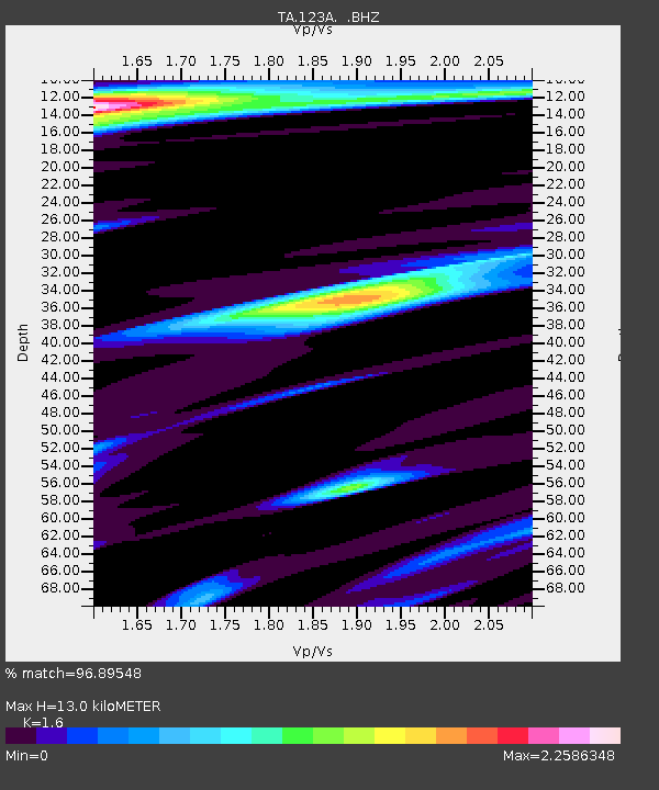
| Estimated Moho Depth: |
13.0 km |
| Estimated Crust Vp/Vs: |
1.60 |
| Assumed Crust Vp: |
6.502 km/s |
| Estimated Crust Vs: |
4.063 km/s |
| Estimated Crust Poisson's Ratio: |
0.18 |
|
| Radial Match: |
96.89548 % |
| Radial Bump: |
301 |
| Transverse Match: |
92.673996 % |
| Transverse Bump: |
373 |
| SOD ConfigId: |
2834 |
| Insert Time: |
2010-03-06 10:49:39.285 +0000 |
| GWidth: |
2.5 |
| Max Bumps: |
400 |
| Tol: |
0.001 |
|

Signal To Noise
| Channel | StoN | STA | LTA |
| TA:123A: :BHZ:20090115T18:00:30.049004Z | 30.067867 | 1.2018799E-5 | 3.9972238E-7 |
| TA:123A: :BHN:20090115T18:00:30.049004Z | 1.3645838 | 4.510633E-6 | 3.3055007E-6 |
| TA:123A: :BHE:20090115T18:00:30.049004Z | 2.688559 | 5.61076E-6 | 2.0869022E-6 |
| Arrivals |
| Ps | 1.2 SECOND |
| PpPs | 5.0 SECOND |
| PsPs/PpSs | 6.2 SECOND |


