You are here: Home > Network List > TA - USArray Transportable Network (new EarthScope stations) Stations List
> Station 123A Bell Site, White Sands Missle Range, NM, USA > Earthquake Result Viewer
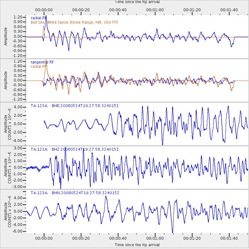
123A Bell Site, White Sands Missle Range, NM, USA - Earthquake Result Viewer
*The percent match for this event was below the threshold and hence no stack was calculated.
| Earthquake location: |
Colombia |
| Earthquake latitude/longitude: |
4.3/-73.8 |
| Earthquake time(UTC): |
2008/05/24 (145) 19:20:42 GMT |
| Earthquake Depth: |
8.9 km |
| Earthquake Magnitude: |
5.6 MB, 5.6 MS, 5.9 MW, 5.9 MW |
| Earthquake Catalog/Contributor: |
WHDF/NEIC |
|
| Network: |
TA USArray Transportable Network (new EarthScope stations) |
| Station: |
123A Bell Site, White Sands Missle Range, NM, USA |
| Lat/Lon: |
32.63 N/106.26 W |
| Elevation: |
1206 m |
|
| Distance: |
41.4 deg |
| Az: |
316.746 deg |
| Baz: |
125.92 deg |
| Ray Param: |
$rayparam |
*The percent match for this event was below the threshold and hence was not used in the summary stack. |
|
| Radial Match: |
62.923885 % |
| Radial Bump: |
400 |
| Transverse Match: |
54.37288 % |
| Transverse Bump: |
373 |
| SOD ConfigId: |
2504 |
| Insert Time: |
2010-03-06 10:49:49.750 +0000 |
| GWidth: |
2.5 |
| Max Bumps: |
400 |
| Tol: |
0.001 |
|
Signal To Noise
| Channel | StoN | STA | LTA |
| TA:123A: :BHZ:20080524T19:27:58.324015Z | 5.654688 | 7.3503685E-7 | 1.2998717E-7 |
| TA:123A: :BHN:20080524T19:27:58.324015Z | 1.5312992 | 1.0270162E-6 | 6.706829E-7 |
| TA:123A: :BHE:20080524T19:27:58.324015Z | 0.9505837 | 6.584841E-7 | 6.9271556E-7 |
| Arrivals |
| Ps | |
| PpPs | |
| PsPs/PpSs | |


