You are here: Home > Network List > CN - Canadian National Seismograph Network Stations List
> Station INK INUVIK, NT > Earthquake Result Viewer
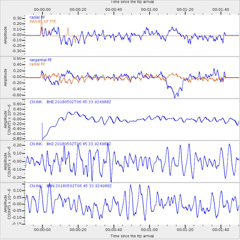
INK INUVIK, NT - Earthquake Result Viewer
*The percent match for this event was below the threshold and hence no stack was calculated.
| Earthquake location: |
Easter Island Region |
| Earthquake latitude/longitude: |
-24.1/-111.7 |
| Earthquake time(UTC): |
2018/05/02 (122) 06:32:52 GMT |
| Earthquake Depth: |
24 km |
| Earthquake Magnitude: |
6.0 Mww |
| Earthquake Catalog/Contributor: |
NEIC PDE/us |
|
| Network: |
CN Canadian National Seismograph Network |
| Station: |
INK INUVIK, NT |
| Lat/Lon: |
68.31 N/133.53 W |
| Elevation: |
44 m |
|
| Distance: |
93.5 deg |
| Az: |
352.048 deg |
| Baz: |
160.12 deg |
| Ray Param: |
$rayparam |
*The percent match for this event was below the threshold and hence was not used in the summary stack. |
|
| Radial Match: |
29.901833 % |
| Radial Bump: |
400 |
| Transverse Match: |
15.720618 % |
| Transverse Bump: |
400 |
| SOD ConfigId: |
13570011 |
| Insert Time: |
2019-04-30 04:37:05.027 +0000 |
| GWidth: |
2.5 |
| Max Bumps: |
400 |
| Tol: |
0.001 |
|
Signal To Noise
| Channel | StoN | STA | LTA |
| CN:INK: :BHZ:20180502T06:45:33.924988Z | 0.9314818 | 7.481099E-8 | 8.031396E-8 |
| CN:INK: :BHN:20180502T06:45:33.924988Z | 1.8814043 | 1.06257204E-7 | 5.64776E-8 |
| CN:INK: :BHE:20180502T06:45:33.924988Z | 0.29226184 | 9.08617E-8 | 3.1089144E-7 |
| Arrivals |
| Ps | |
| PpPs | |
| PsPs/PpSs | |


