You are here: Home > Network List > TA - USArray Transportable Network (new EarthScope stations) Stations List
> Station 109C Camp Elliot, Mirimar, CA, USA > Earthquake Result Viewer
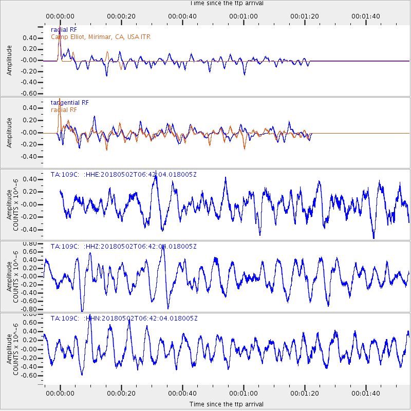
109C Camp Elliot, Mirimar, CA, USA - Earthquake Result Viewer
*The percent match for this event was below the threshold and hence no stack was calculated.
| Earthquake location: |
Easter Island Region |
| Earthquake latitude/longitude: |
-24.1/-111.7 |
| Earthquake time(UTC): |
2018/05/02 (122) 06:32:52 GMT |
| Earthquake Depth: |
24 km |
| Earthquake Magnitude: |
6.0 Mww |
| Earthquake Catalog/Contributor: |
NEIC PDE/us |
|
| Network: |
TA USArray Transportable Network (new EarthScope stations) |
| Station: |
109C Camp Elliot, Mirimar, CA, USA |
| Lat/Lon: |
32.89 N/117.11 W |
| Elevation: |
150 m |
|
| Distance: |
56.9 deg |
| Az: |
354.595 deg |
| Baz: |
174.128 deg |
| Ray Param: |
$rayparam |
*The percent match for this event was below the threshold and hence was not used in the summary stack. |
|
| Radial Match: |
56.23429 % |
| Radial Bump: |
351 |
| Transverse Match: |
60.127045 % |
| Transverse Bump: |
400 |
| SOD ConfigId: |
13570011 |
| Insert Time: |
2019-04-30 04:40:37.037 +0000 |
| GWidth: |
2.5 |
| Max Bumps: |
400 |
| Tol: |
0.001 |
|
Signal To Noise
| Channel | StoN | STA | LTA |
| TA:109C: :HHZ:20180502T06:42:04.018005Z | 0.6465644 | 1.2881192E-7 | 1.9922518E-7 |
| TA:109C: :HHN:20180502T06:42:04.018005Z | 0.60823536 | 1.1944171E-7 | 1.9637415E-7 |
| TA:109C: :HHE:20180502T06:42:04.018005Z | 2.5856092 | 2.966276E-7 | 1.1472253E-7 |
| Arrivals |
| Ps | |
| PpPs | |
| PsPs/PpSs | |


