You are here: Home > Network List > TA - USArray Transportable Network (new EarthScope stations) Stations List
> Station 123A Bell Site, White Sands Missle Range, NM, USA > Earthquake Result Viewer
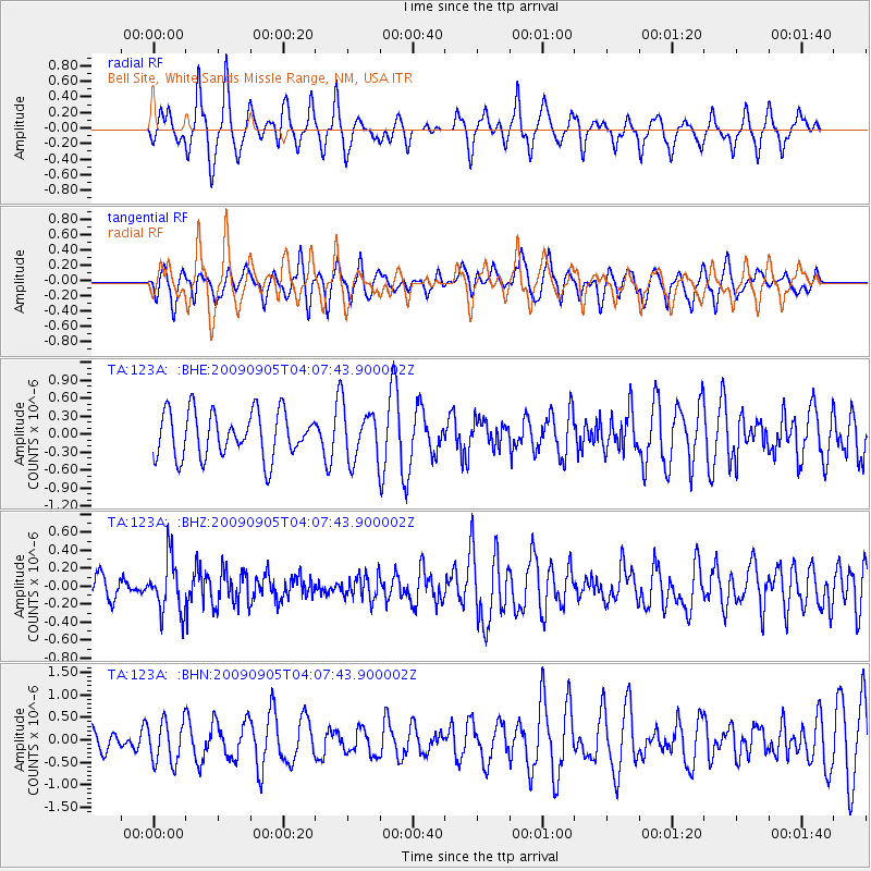
123A Bell Site, White Sands Missle Range, NM, USA - Earthquake Result Viewer
*The percent match for this event was below the threshold and hence no stack was calculated.
| Earthquake location: |
Southern Peru |
| Earthquake latitude/longitude: |
-15.1/-70.2 |
| Earthquake time(UTC): |
2009/09/05 (248) 03:58:39 GMT |
| Earthquake Depth: |
210 km |
| Earthquake Magnitude: |
5.8 MW, 5.2 MB, 5.8 MW |
| Earthquake Catalog/Contributor: |
WHDF/NEIC |
|
| Network: |
TA USArray Transportable Network (new EarthScope stations) |
| Station: |
123A Bell Site, White Sands Missle Range, NM, USA |
| Lat/Lon: |
32.63 N/106.26 W |
| Elevation: |
1206 m |
|
| Distance: |
58.7 deg |
| Az: |
324.491 deg |
| Baz: |
138.329 deg |
| Ray Param: |
$rayparam |
*The percent match for this event was below the threshold and hence was not used in the summary stack. |
|
| Radial Match: |
56.08618 % |
| Radial Bump: |
337 |
| Transverse Match: |
53.967762 % |
| Transverse Bump: |
389 |
| SOD ConfigId: |
2622 |
| Insert Time: |
2010-03-06 10:50:18.435 +0000 |
| GWidth: |
2.5 |
| Max Bumps: |
400 |
| Tol: |
0.001 |
|
Signal To Noise
| Channel | StoN | STA | LTA |
| TA:123A: :BHZ:20090905T04:07:43.900002Z | 2.7300482 | 3.0058945E-7 | 1.10104075E-7 |
| TA:123A: :BHN:20090905T04:07:43.900002Z | 1.2986392 | 4.6538116E-7 | 3.5836064E-7 |
| TA:123A: :BHE:20090905T04:07:43.900002Z | 1.1301947 | 4.292221E-7 | 3.7977713E-7 |
| Arrivals |
| Ps | |
| PpPs | |
| PsPs/PpSs | |


