You are here: Home > Network List > TA - USArray Transportable Network (new EarthScope stations) Stations List
> Station 123A Bell Site, White Sands Missle Range, NM, USA > Earthquake Result Viewer
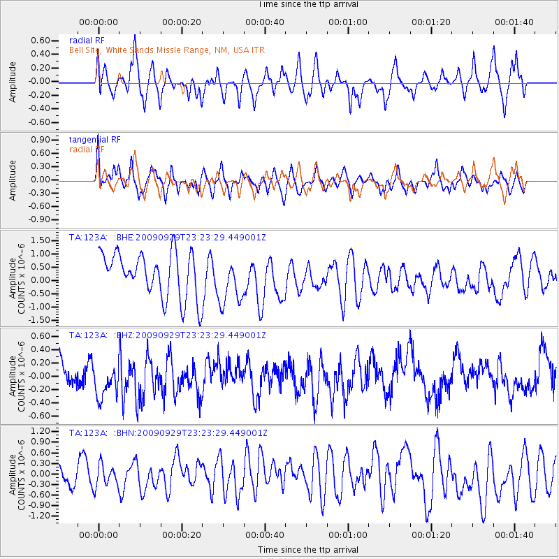
123A Bell Site, White Sands Missle Range, NM, USA - Earthquake Result Viewer
*The percent match for this event was below the threshold and hence no stack was calculated.
| Earthquake location: |
Tonga Islands |
| Earthquake latitude/longitude: |
-15.6/-173.4 |
| Earthquake time(UTC): |
2009/09/29 (272) 23:11:51 GMT |
| Earthquake Depth: |
10 km |
| Earthquake Magnitude: |
5.5 MB |
| Earthquake Catalog/Contributor: |
WHDF/NEIC |
|
| Network: |
TA USArray Transportable Network (new EarthScope stations) |
| Station: |
123A Bell Site, White Sands Missle Range, NM, USA |
| Lat/Lon: |
32.63 N/106.26 W |
| Elevation: |
1206 m |
|
| Distance: |
80.1 deg |
| Az: |
52.109 deg |
| Baz: |
244.325 deg |
| Ray Param: |
$rayparam |
*The percent match for this event was below the threshold and hence was not used in the summary stack. |
|
| Radial Match: |
52.28361 % |
| Radial Bump: |
400 |
| Transverse Match: |
48.48662 % |
| Transverse Bump: |
364 |
| SOD ConfigId: |
2622 |
| Insert Time: |
2010-03-06 10:50:24.332 +0000 |
| GWidth: |
2.5 |
| Max Bumps: |
400 |
| Tol: |
0.001 |
|
Signal To Noise
| Channel | StoN | STA | LTA |
| TA:123A: :BHZ:20090929T23:23:29.449001Z | 1.4234091 | 3.1263713E-7 | 2.1963967E-7 |
| TA:123A: :BHN:20090929T23:23:29.449001Z | 0.5266851 | 3.0050188E-7 | 5.705532E-7 |
| TA:123A: :BHE:20090929T23:23:29.449001Z | 1.0686146 | 9.0264757E-7 | 8.4468957E-7 |
| Arrivals |
| Ps | |
| PpPs | |
| PsPs/PpSs | |


