You are here: Home > Network List > TA - USArray Transportable Network (new EarthScope stations) Stations List
> Station 123A Bell Site, White Sands Missle Range, NM, USA > Earthquake Result Viewer
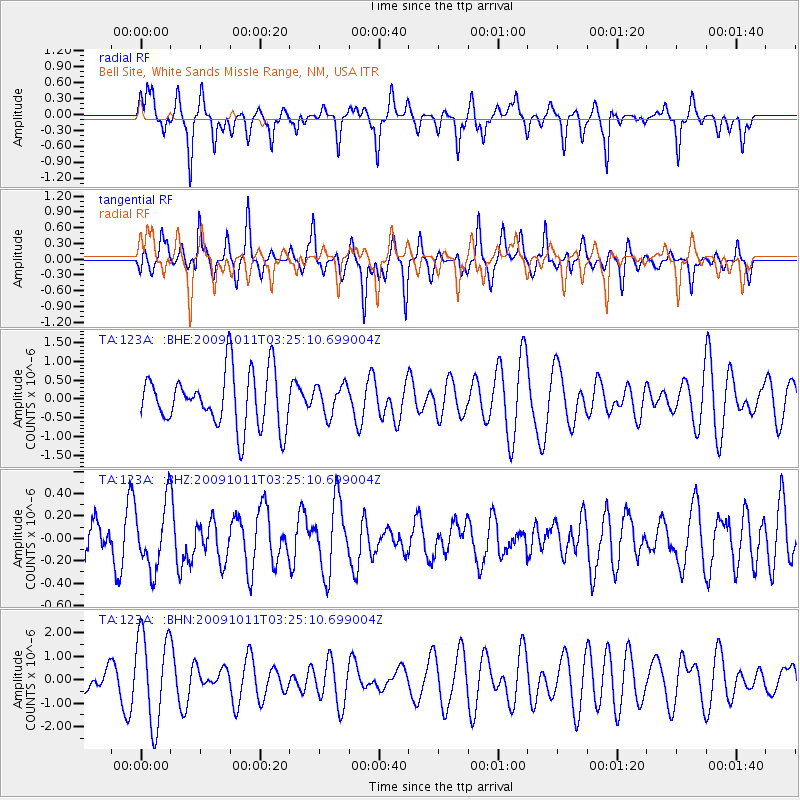
123A Bell Site, White Sands Missle Range, NM, USA - Earthquake Result Viewer
*The percent match for this event was below the threshold and hence no stack was calculated.
| Earthquake location: |
Southeast Of Loyalty Islands |
| Earthquake latitude/longitude: |
-22.0/170.2 |
| Earthquake time(UTC): |
2009/10/11 (284) 03:12:13 GMT |
| Earthquake Depth: |
10 km |
| Earthquake Magnitude: |
5.7 MB, 5.5 MS, 6.0 MW, 5.9 MW |
| Earthquake Catalog/Contributor: |
WHDF/NEIC |
|
| Network: |
TA USArray Transportable Network (new EarthScope stations) |
| Station: |
123A Bell Site, White Sands Missle Range, NM, USA |
| Lat/Lon: |
32.63 N/106.26 W |
| Elevation: |
1206 m |
|
| Distance: |
96.4 deg |
| Az: |
57.516 deg |
| Baz: |
248.097 deg |
| Ray Param: |
$rayparam |
*The percent match for this event was below the threshold and hence was not used in the summary stack. |
|
| Radial Match: |
56.96053 % |
| Radial Bump: |
278 |
| Transverse Match: |
44.99815 % |
| Transverse Bump: |
307 |
| SOD ConfigId: |
2622 |
| Insert Time: |
2010-03-06 10:50:34.635 +0000 |
| GWidth: |
2.5 |
| Max Bumps: |
400 |
| Tol: |
0.001 |
|
Signal To Noise
| Channel | StoN | STA | LTA |
| TA:123A: :BHZ:20091011T03:25:10.699004Z | 2.6869588 | 2.891886E-7 | 1.0762673E-7 |
| TA:123A: :BHN:20091011T03:25:10.699004Z | 3.403501 | 1.9234237E-6 | 5.651309E-7 |
| TA:123A: :BHE:20091011T03:25:10.699004Z | 0.5487027 | 4.0180035E-7 | 7.322733E-7 |
| Arrivals |
| Ps | |
| PpPs | |
| PsPs/PpSs | |


