You are here: Home > Network List > TA - USArray Transportable Network (new EarthScope stations) Stations List
> Station 123A Bell Site, White Sands Missle Range, NM, USA > Earthquake Result Viewer
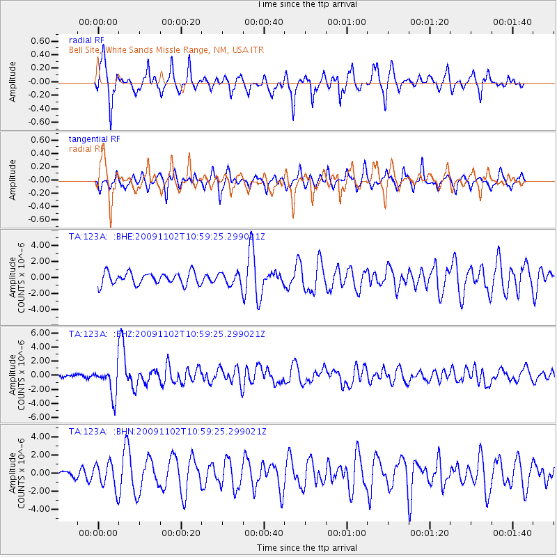
123A Bell Site, White Sands Missle Range, NM, USA - Earthquake Result Viewer
*The percent match for this event was below the threshold and hence no stack was calculated.
| Earthquake location: |
South Of Tonga Islands |
| Earthquake latitude/longitude: |
-24.1/-175.2 |
| Earthquake time(UTC): |
2009/11/02 (306) 10:47:13 GMT |
| Earthquake Depth: |
9.0 km |
| Earthquake Magnitude: |
6.1 MB, 6.1 MS, 6.2 MW, 6.1 MW |
| Earthquake Catalog/Contributor: |
WHDF/NEIC |
|
| Network: |
TA USArray Transportable Network (new EarthScope stations) |
| Station: |
123A Bell Site, White Sands Missle Range, NM, USA |
| Lat/Lon: |
32.63 N/106.26 W |
| Elevation: |
1206 m |
|
| Distance: |
86.6 deg |
| Az: |
52.058 deg |
| Baz: |
238.65 deg |
| Ray Param: |
$rayparam |
*The percent match for this event was below the threshold and hence was not used in the summary stack. |
|
| Radial Match: |
78.412575 % |
| Radial Bump: |
362 |
| Transverse Match: |
64.5525 % |
| Transverse Bump: |
397 |
| SOD ConfigId: |
2622 |
| Insert Time: |
2010-03-06 10:50:49.590 +0000 |
| GWidth: |
2.5 |
| Max Bumps: |
400 |
| Tol: |
0.001 |
|
Signal To Noise
| Channel | StoN | STA | LTA |
| TA:123A: :BHZ:20091102T10:59:25.299021Z | 9.798873 | 2.1282503E-6 | 2.1719339E-7 |
| TA:123A: :BHN:20091102T10:59:25.299021Z | 1.7663075 | 1.460995E-6 | 8.271465E-7 |
| TA:123A: :BHE:20091102T10:59:25.299021Z | 1.0598423 | 8.0868045E-7 | 7.630196E-7 |
| Arrivals |
| Ps | |
| PpPs | |
| PsPs/PpSs | |


