You are here: Home > Network List > TA - USArray Transportable Network (new EarthScope stations) Stations List
> Station 123A Bell Site, White Sands Missle Range, NM, USA > Earthquake Result Viewer
123A Bell Site, White Sands Missle Range, NM, USA - Earthquake Result Viewer
*The percent match for this event was below the threshold and hence no stack was calculated.
| Earthquake location: |
E. Russia-N.E. China Border Reg. |
| Earthquake latitude/longitude: |
42.5/131.9 |
| Earthquake time(UTC): |
2008/05/19 (140) 10:08:36 GMT |
| Earthquake Depth: |
513 km |
| Earthquake Magnitude: |
5.7 MW, 5.4 MB, 5.6 MW |
| Earthquake Catalog/Contributor: |
WHDF/NEIC |
|
| Network: |
TA USArray Transportable Network (new EarthScope stations) |
| Station: |
123A Bell Site, White Sands Missle Range, NM, USA |
| Lat/Lon: |
32.63 N/106.26 W |
| Elevation: |
1206 m |
|
| Distance: |
88.2 deg |
| Az: |
45.804 deg |
| Baz: |
321.07 deg |
| Ray Param: |
$rayparam |
*The percent match for this event was below the threshold and hence was not used in the summary stack. |
|
| Radial Match: |
35.302044 % |
| Radial Bump: |
299 |
| Transverse Match: |
52.17736 % |
| Transverse Bump: |
325 |
| SOD ConfigId: |
2504 |
| Insert Time: |
2010-03-06 10:51:39.366 +0000 |
| GWidth: |
2.5 |
| Max Bumps: |
400 |
| Tol: |
0.001 |
|
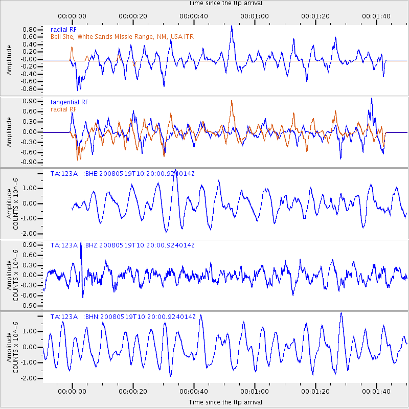
Signal To Noise
| Channel | StoN | STA | LTA |
| TA:123A: :BHZ:20080519T10:20:00.924014Z | 1.8013368 | 3.5521944E-7 | 1.9719768E-7 |
| TA:123A: :BHN:20080519T10:20:00.924014Z | 1.1255573 | 7.585458E-7 | 6.7392915E-7 |
| TA:123A: :BHE:20080519T10:20:00.924014Z | 2.325095 | 1.3875089E-6 | 5.9675364E-7 |
| Arrivals |
| Ps | |
| PpPs | |
| PsPs/PpSs | |


