TOV Thousand Oaks, California, USA - Earthquake Result Viewer
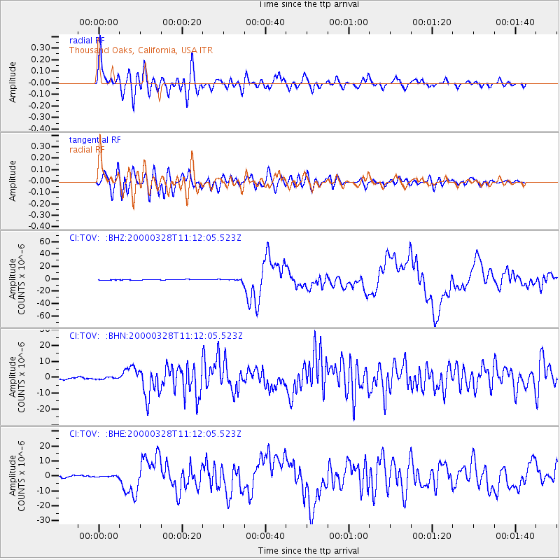
Earthquake location: Volcano Islands, Japan Region
Earthquake latitude/longitude: 22.3/143.7
Earthquake time(UTC): 2000/03/28 (088) 11:00:22 GMT
Earthquake Depth: 126 km
Earthquake Magnitude: 6.8 MB, 7.6 MS, 7.6 MW, 7.6 MW
Earthquake Catalog/Contributor: WHDF/NEIC
Network: CI Caltech Regional Seismic Network
Station: TOV Thousand Oaks, California, USA
Lat/Lon: 34.16 N/118.82 W
Elevation: 50 m
Distance: 83.6 deg
Az: 55.835 deg
Baz: 292.511 deg
Ray Param: 0.04579238
Estimated Moho Depth: 11.5 km
Estimated Crust Vp/Vs: 1.60
Assumed Crust Vp: 6.1 km/s
Estimated Crust Vs: 3.807 km/s
Estimated Crust Poisson's Ratio: 0.18
Radial Match: 93.532875 %
Radial Bump: 400
Transverse Match: 82.99776 %
Transverse Bump: 400
SOD ConfigId: 3744
Insert Time: 2010-02-26 01:56:17.474 +0000
GWidth: 2.5
Max Bumps: 400
Tol: 0.001

Signal To Noise

ChannelStoNSTALTA
CI:TOV: :BHN:20000328T11:12:05.523Z0.88487135.9436024E-76.7169117E-7
CI:TOV: :BHE:20000328T11:12:05.523Z0.605564833.3099016E-75.4658085E-7
CI:TOV: :BHZ:20000328T11:12:05.523Z3.95780321.9277327E-64.8707136E-7
Arrivals
Ps1.2 SECOND
PpPs4.8 SECOND
PsPs/PpSs5.9 SECOND