You are here: Home > Network List > TA - USArray Transportable Network (new EarthScope stations) Stations List
> Station A36M Sachs Harbour, NT, CAN > Earthquake Result Viewer
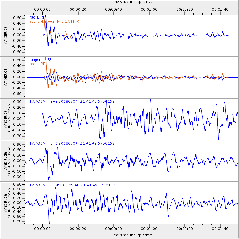
A36M Sachs Harbour, NT, CAN - Earthquake Result Viewer
*The percent match for this event was below the threshold and hence no stack was calculated.
| Earthquake location: |
Hawaii |
| Earthquake latitude/longitude: |
19.3/-155.0 |
| Earthquake time(UTC): |
2018/05/04 (124) 21:32:44 GMT |
| Earthquake Depth: |
6.9 km |
| Earthquake Magnitude: |
5.7 Ml |
| Earthquake Catalog/Contributor: |
NEIC PDE/hv |
|
| Network: |
TA USArray Transportable Network (new EarthScope stations) |
| Station: |
A36M Sachs Harbour, NT, CAN |
| Lat/Lon: |
71.99 N/125.25 W |
| Elevation: |
32 m |
|
| Distance: |
55.4 deg |
| Az: |
10.822 deg |
| Baz: |
214.739 deg |
| Ray Param: |
$rayparam |
*The percent match for this event was below the threshold and hence was not used in the summary stack. |
|
| Radial Match: |
86.77386 % |
| Radial Bump: |
400 |
| Transverse Match: |
68.63628 % |
| Transverse Bump: |
400 |
| SOD ConfigId: |
13570011 |
| Insert Time: |
2019-04-30 04:50:28.690 +0000 |
| GWidth: |
2.5 |
| Max Bumps: |
400 |
| Tol: |
0.001 |
|
Signal To Noise
| Channel | StoN | STA | LTA |
| TA:A36M: :BHZ:20180504T21:41:49.575015Z | 8.265248 | 5.344124E-7 | 6.4657755E-8 |
| TA:A36M: :BHN:20180504T21:41:49.575015Z | 7.6907845 | 3.6254957E-7 | 4.7140777E-8 |
| TA:A36M: :BHE:20180504T21:41:49.575015Z | 2.3910267 | 1.6817006E-7 | 7.0333826E-8 |
| Arrivals |
| Ps | |
| PpPs | |
| PsPs/PpSs | |


