You are here: Home > Network List > TA - USArray Transportable Network (new EarthScope stations) Stations List
> Station C16K Lisburne Hills, AK, USA > Earthquake Result Viewer
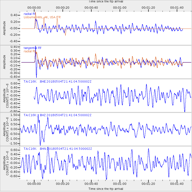
C16K Lisburne Hills, AK, USA - Earthquake Result Viewer
*The percent match for this event was below the threshold and hence no stack was calculated.
| Earthquake location: |
Hawaii |
| Earthquake latitude/longitude: |
19.3/-155.0 |
| Earthquake time(UTC): |
2018/05/04 (124) 21:32:44 GMT |
| Earthquake Depth: |
6.9 km |
| Earthquake Magnitude: |
5.7 Ml |
| Earthquake Catalog/Contributor: |
NEIC PDE/hv |
|
| Network: |
TA USArray Transportable Network (new EarthScope stations) |
| Station: |
C16K Lisburne Hills, AK, USA |
| Lat/Lon: |
68.27 N/165.34 W |
| Elevation: |
102 m |
|
| Distance: |
49.4 deg |
| Az: |
354.961 deg |
| Baz: |
167.128 deg |
| Ray Param: |
$rayparam |
*The percent match for this event was below the threshold and hence was not used in the summary stack. |
|
| Radial Match: |
71.771675 % |
| Radial Bump: |
400 |
| Transverse Match: |
74.46109 % |
| Transverse Bump: |
400 |
| SOD ConfigId: |
13570011 |
| Insert Time: |
2019-04-30 04:50:35.195 +0000 |
| GWidth: |
2.5 |
| Max Bumps: |
400 |
| Tol: |
0.001 |
|
Signal To Noise
| Channel | StoN | STA | LTA |
| TA:C16K: :BHZ:20180504T21:41:04.500002Z | 4.01127 | 8.0364254E-7 | 2.0034616E-7 |
| TA:C16K: :BHN:20180504T21:41:04.500002Z | 1.1984365 | 2.5970635E-7 | 2.1670432E-7 |
| TA:C16K: :BHE:20180504T21:41:04.500002Z | 1.5526732 | 2.7771844E-7 | 1.7886471E-7 |
| Arrivals |
| Ps | |
| PpPs | |
| PsPs/PpSs | |


