You are here: Home > Network List > TA - USArray Transportable Network (new EarthScope stations) Stations List
> Station D23K Nanushuk River, AK USA > Earthquake Result Viewer
D23K Nanushuk River, AK USA - Earthquake Result Viewer
*The percent match for this event was below the threshold and hence no stack was calculated.
| Earthquake location: |
Hawaii |
| Earthquake latitude/longitude: |
19.3/-155.0 |
| Earthquake time(UTC): |
2018/05/04 (124) 21:32:44 GMT |
| Earthquake Depth: |
6.9 km |
| Earthquake Magnitude: |
5.7 Ml |
| Earthquake Catalog/Contributor: |
NEIC PDE/hv |
|
| Network: |
TA USArray Transportable Network (new EarthScope stations) |
| Station: |
D23K Nanushuk River, AK USA |
| Lat/Lon: |
68.97 N/150.68 W |
| Elevation: |
406 m |
|
| Distance: |
49.7 deg |
| Az: |
2.059 deg |
| Baz: |
185.391 deg |
| Ray Param: |
$rayparam |
*The percent match for this event was below the threshold and hence was not used in the summary stack. |
|
| Radial Match: |
79.26999 % |
| Radial Bump: |
400 |
| Transverse Match: |
61.035095 % |
| Transverse Bump: |
400 |
| SOD ConfigId: |
13570011 |
| Insert Time: |
2019-04-30 04:50:46.190 +0000 |
| GWidth: |
2.5 |
| Max Bumps: |
400 |
| Tol: |
0.001 |
|
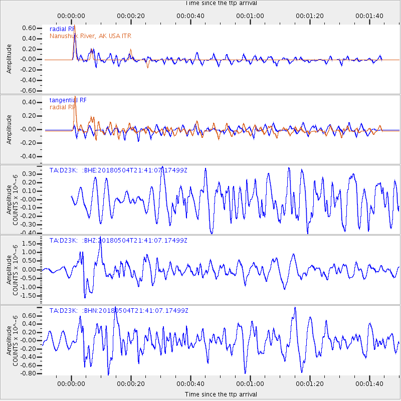
Signal To Noise
| Channel | StoN | STA | LTA |
| TA:D23K: :BHZ:20180504T21:41:07.17499Z | 4.650124 | 6.7138717E-7 | 1.4438048E-7 |
| TA:D23K: :BHN:20180504T21:41:07.17499Z | 1.6315596 | 2.9500237E-7 | 1.8081003E-7 |
| TA:D23K: :BHE:20180504T21:41:07.17499Z | 1.9252878 | 2.3126547E-7 | 1.2011995E-7 |
| Arrivals |
| Ps | |
| PpPs | |
| PsPs/PpSs | |


