You are here: Home > Network List > TA - USArray Transportable Network (new EarthScope stations) Stations List
> Station 123A Bell Site, White Sands Missle Range, NM, USA > Earthquake Result Viewer
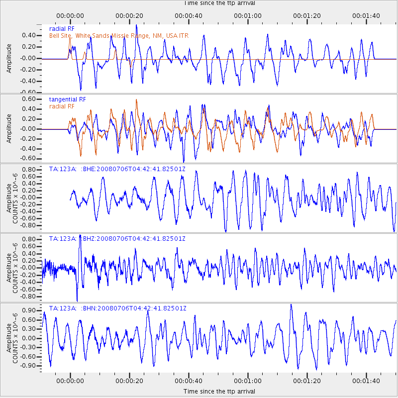
123A Bell Site, White Sands Missle Range, NM, USA - Earthquake Result Viewer
*The percent match for this event was below the threshold and hence no stack was calculated.
| Earthquake location: |
South Of Fiji Islands |
| Earthquake latitude/longitude: |
-25.5/-176.4 |
| Earthquake time(UTC): |
2008/07/06 (188) 04:30:26 GMT |
| Earthquake Depth: |
49 km |
| Earthquake Magnitude: |
5.5 MB, 5.3 MS |
| Earthquake Catalog/Contributor: |
WHDF/NEIC |
|
| Network: |
TA USArray Transportable Network (new EarthScope stations) |
| Station: |
123A Bell Site, White Sands Missle Range, NM, USA |
| Lat/Lon: |
32.63 N/106.26 W |
| Elevation: |
1206 m |
|
| Distance: |
88.3 deg |
| Az: |
52.532 deg |
| Baz: |
238.251 deg |
| Ray Param: |
$rayparam |
*The percent match for this event was below the threshold and hence was not used in the summary stack. |
|
| Radial Match: |
56.83913 % |
| Radial Bump: |
400 |
| Transverse Match: |
57.77995 % |
| Transverse Bump: |
400 |
| SOD ConfigId: |
2504 |
| Insert Time: |
2010-03-06 10:51:57.575 +0000 |
| GWidth: |
2.5 |
| Max Bumps: |
400 |
| Tol: |
0.001 |
|
Signal To Noise
| Channel | StoN | STA | LTA |
| TA:123A: :BHZ:20080706T04:42:41.82501Z | 3.133647 | 4.0174396E-7 | 1.2820333E-7 |
| TA:123A: :BHN:20080706T04:42:41.82501Z | 0.91668975 | 4.2536698E-7 | 4.64025E-7 |
| TA:123A: :BHE:20080706T04:42:41.82501Z | 1.5195591 | 3.495926E-7 | 2.3006186E-7 |
| Arrivals |
| Ps | |
| PpPs | |
| PsPs/PpSs | |


