You are here: Home > Network List > TA - USArray Transportable Network (new EarthScope stations) Stations List
> Station G21K Allakaket, AK, USA > Earthquake Result Viewer
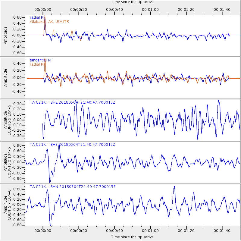
G21K Allakaket, AK, USA - Earthquake Result Viewer
*The percent match for this event was below the threshold and hence no stack was calculated.
| Earthquake location: |
Hawaii |
| Earthquake latitude/longitude: |
19.3/-155.0 |
| Earthquake time(UTC): |
2018/05/04 (124) 21:32:44 GMT |
| Earthquake Depth: |
6.9 km |
| Earthquake Magnitude: |
5.7 Ml |
| Earthquake Catalog/Contributor: |
NEIC PDE/hv |
|
| Network: |
TA USArray Transportable Network (new EarthScope stations) |
| Station: |
G21K Allakaket, AK, USA |
| Lat/Lon: |
66.52 N/153.51 W |
| Elevation: |
446 m |
|
| Distance: |
47.2 deg |
| Az: |
0.834 deg |
| Baz: |
181.965 deg |
| Ray Param: |
$rayparam |
*The percent match for this event was below the threshold and hence was not used in the summary stack. |
|
| Radial Match: |
75.17328 % |
| Radial Bump: |
302 |
| Transverse Match: |
67.980576 % |
| Transverse Bump: |
400 |
| SOD ConfigId: |
13570011 |
| Insert Time: |
2019-04-30 04:51:12.059 +0000 |
| GWidth: |
2.5 |
| Max Bumps: |
400 |
| Tol: |
0.001 |
|
Signal To Noise
| Channel | StoN | STA | LTA |
| TA:G21K: :BHZ:20180504T21:40:47.700015Z | 4.4788976 | 5.34337E-7 | 1.1930102E-7 |
| TA:G21K: :BHN:20180504T21:40:47.700015Z | 2.7660778 | 4.0019583E-7 | 1.4467989E-7 |
| TA:G21K: :BHE:20180504T21:40:47.700015Z | 0.59393054 | 9.17357E-8 | 1.5445528E-7 |
| Arrivals |
| Ps | |
| PpPs | |
| PsPs/PpSs | |


