You are here: Home > Network List > TA - USArray Transportable Network (new EarthScope stations) Stations List
> Station 123A Bell Site, White Sands Missle Range, NM, USA > Earthquake Result Viewer
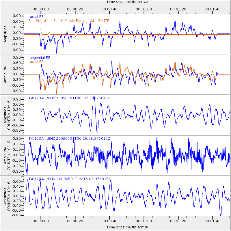
123A Bell Site, White Sands Missle Range, NM, USA - Earthquake Result Viewer
*The percent match for this event was below the threshold and hence no stack was calculated.
| Earthquake location: |
Solomon Islands |
| Earthquake latitude/longitude: |
-10.8/162.2 |
| Earthquake time(UTC): |
2009/05/01 (121) 06:03:05 GMT |
| Earthquake Depth: |
21 km |
| Earthquake Magnitude: |
5.9 MB, 5.6 MS, 5.9 MW, 5.9 MW |
| Earthquake Catalog/Contributor: |
WHDF/NEIC |
|
| Network: |
TA USArray Transportable Network (new EarthScope stations) |
| Station: |
123A Bell Site, White Sands Missle Range, NM, USA |
| Lat/Lon: |
32.63 N/106.26 W |
| Elevation: |
1206 m |
|
| Distance: |
97.0 deg |
| Az: |
58.187 deg |
| Baz: |
261.736 deg |
| Ray Param: |
$rayparam |
*The percent match for this event was below the threshold and hence was not used in the summary stack. |
|
| Radial Match: |
50.457203 % |
| Radial Bump: |
400 |
| Transverse Match: |
55.06256 % |
| Transverse Bump: |
400 |
| SOD ConfigId: |
2658 |
| Insert Time: |
2010-03-06 10:52:21.125 +0000 |
| GWidth: |
2.5 |
| Max Bumps: |
400 |
| Tol: |
0.001 |
|
Signal To Noise
| Channel | StoN | STA | LTA |
| TA:123A: :BHZ:20090501T06:16:03.975015Z | 0.52779573 | 7.143747E-8 | 1.353506E-7 |
| TA:123A: :BHN:20090501T06:16:03.975015Z | 1.3723218 | 4.055138E-7 | 2.9549466E-7 |
| TA:123A: :BHE:20090501T06:16:03.975015Z | 2.9928715 | 6.996471E-7 | 2.3377119E-7 |
| Arrivals |
| Ps | |
| PpPs | |
| PsPs/PpSs | |


