You are here: Home > Network List > TA - USArray Transportable Network (new EarthScope stations) Stations List
> Station T25A Trinidad, CO, USA > Earthquake Result Viewer
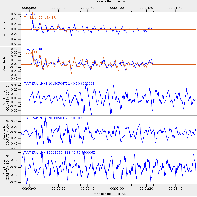
T25A Trinidad, CO, USA - Earthquake Result Viewer
*The percent match for this event was below the threshold and hence no stack was calculated.
| Earthquake location: |
Hawaii |
| Earthquake latitude/longitude: |
19.3/-155.0 |
| Earthquake time(UTC): |
2018/05/04 (124) 21:32:44 GMT |
| Earthquake Depth: |
6.9 km |
| Earthquake Magnitude: |
5.7 Ml |
| Earthquake Catalog/Contributor: |
NEIC PDE/hv |
|
| Network: |
TA USArray Transportable Network (new EarthScope stations) |
| Station: |
T25A Trinidad, CO, USA |
| Lat/Lon: |
37.14 N/104.41 W |
| Elevation: |
2017 m |
|
| Distance: |
47.4 deg |
| Az: |
57.026 deg |
| Baz: |
262.426 deg |
| Ray Param: |
$rayparam |
*The percent match for this event was below the threshold and hence was not used in the summary stack. |
|
| Radial Match: |
73.38678 % |
| Radial Bump: |
400 |
| Transverse Match: |
51.561497 % |
| Transverse Bump: |
400 |
| SOD ConfigId: |
13570011 |
| Insert Time: |
2019-04-30 04:52:34.368 +0000 |
| GWidth: |
2.5 |
| Max Bumps: |
400 |
| Tol: |
0.001 |
|
Signal To Noise
| Channel | StoN | STA | LTA |
| TA:T25A: :HHZ:20180504T21:40:50.660006Z | 1.3788038 | 9.562296E-8 | 6.935211E-8 |
| TA:T25A: :HHN:20180504T21:40:50.660006Z | 1.2380263 | 6.727581E-8 | 5.4341182E-8 |
| TA:T25A: :HHE:20180504T21:40:50.660006Z | 1.3016629 | 8.8648065E-8 | 6.81037E-8 |
| Arrivals |
| Ps | |
| PpPs | |
| PsPs/PpSs | |


