You are here: Home > Network List > TA - USArray Transportable Network (new EarthScope stations) Stations List
> Station 123A Bell Site, White Sands Missle Range, NM, USA > Earthquake Result Viewer
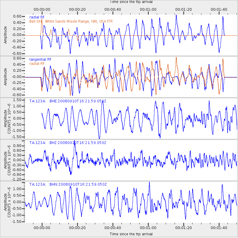
123A Bell Site, White Sands Missle Range, NM, USA - Earthquake Result Viewer
*The percent match for this event was below the threshold and hence no stack was calculated.
| Earthquake location: |
Northern Chile |
| Earthquake latitude/longitude: |
-20.3/-69.2 |
| Earthquake time(UTC): |
2008/09/10 (254) 16:12:04 GMT |
| Earthquake Depth: |
38 km |
| Earthquake Magnitude: |
5.6 MB, 5.3 MS |
| Earthquake Catalog/Contributor: |
WHDF/NEIC |
|
| Network: |
TA USArray Transportable Network (new EarthScope stations) |
| Station: |
123A Bell Site, White Sands Missle Range, NM, USA |
| Lat/Lon: |
32.63 N/106.26 W |
| Elevation: |
1206 m |
|
| Distance: |
63.4 deg |
| Az: |
325.365 deg |
| Baz: |
140.772 deg |
| Ray Param: |
$rayparam |
*The percent match for this event was below the threshold and hence was not used in the summary stack. |
|
| Radial Match: |
50.127895 % |
| Radial Bump: |
382 |
| Transverse Match: |
61.03259 % |
| Transverse Bump: |
377 |
| SOD ConfigId: |
2560 |
| Insert Time: |
2010-03-06 10:52:42.693 +0000 |
| GWidth: |
2.5 |
| Max Bumps: |
400 |
| Tol: |
0.001 |
|
Signal To Noise
| Channel | StoN | STA | LTA |
| TA:123A: :BHZ:20080910T16:21:59.050Z | 2.0590868 | 3.188587E-7 | 1.5485442E-7 |
| TA:123A: :BHN:20080910T16:21:59.050Z | 1.009283 | 2.8608352E-7 | 2.8345224E-7 |
| TA:123A: :BHE:20080910T16:21:59.050Z | 1.7158748 | 9.279524E-7 | 5.4080425E-7 |
| Arrivals |
| Ps | |
| PpPs | |
| PsPs/PpSs | |


