You are here: Home > Network List > TA - USArray Transportable Network (new EarthScope stations) Stations List
> Station 123A Bell Site, White Sands Missle Range, NM, USA > Earthquake Result Viewer
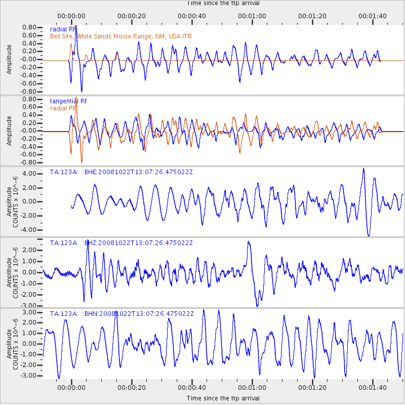
123A Bell Site, White Sands Missle Range, NM, USA - Earthquake Result Viewer
*The percent match for this event was below the threshold and hence no stack was calculated.
| Earthquake location: |
Tonga Islands |
| Earthquake latitude/longitude: |
-18.4/-175.4 |
| Earthquake time(UTC): |
2008/10/22 (296) 12:55:57 GMT |
| Earthquake Depth: |
233 km |
| Earthquake Magnitude: |
5.9 MB, 6.4 MW, 6.3 MW |
| Earthquake Catalog/Contributor: |
WHDF/NEIC |
|
| Network: |
TA USArray Transportable Network (new EarthScope stations) |
| Station: |
123A Bell Site, White Sands Missle Range, NM, USA |
| Lat/Lon: |
32.63 N/106.26 W |
| Elevation: |
1206 m |
|
| Distance: |
83.3 deg |
| Az: |
52.531 deg |
| Baz: |
243.262 deg |
| Ray Param: |
$rayparam |
*The percent match for this event was below the threshold and hence was not used in the summary stack. |
|
| Radial Match: |
46.430206 % |
| Radial Bump: |
400 |
| Transverse Match: |
48.361965 % |
| Transverse Bump: |
360 |
| SOD ConfigId: |
2560 |
| Insert Time: |
2010-03-06 10:52:48.264 +0000 |
| GWidth: |
2.5 |
| Max Bumps: |
400 |
| Tol: |
0.001 |
|
Signal To Noise
| Channel | StoN | STA | LTA |
| TA:123A: :BHZ:20081022T13:07:26.475022Z | 3.0222485 | 6.9124945E-7 | 2.2872027E-7 |
| TA:123A: :BHN:20081022T13:07:26.475022Z | 1.3881726 | 1.3248911E-6 | 9.544137E-7 |
| TA:123A: :BHE:20081022T13:07:26.475022Z | 1.5238062 | 1.5707591E-6 | 1.0308129E-6 |
| Arrivals |
| Ps | |
| PpPs | |
| PsPs/PpSs | |


