You are here: Home > Network List > UW - Pacific Northwest Regional Seismic Network Stations List
> Station FISH Seaside, OR, USA > Earthquake Result Viewer
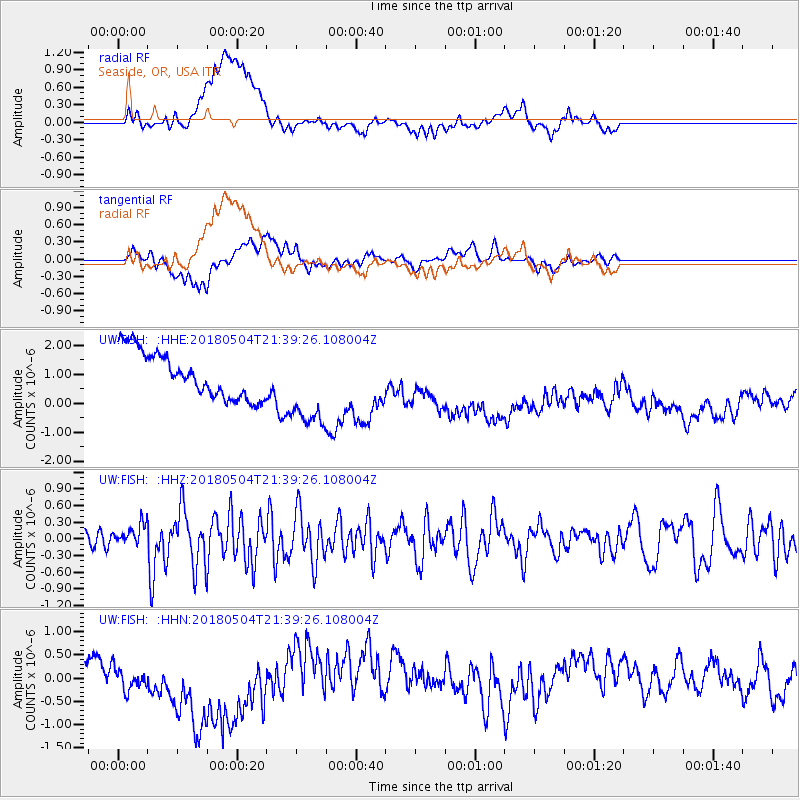
FISH Seaside, OR, USA - Earthquake Result Viewer
*The percent match for this event was below the threshold and hence no stack was calculated.
| Earthquake location: |
Hawaii |
| Earthquake latitude/longitude: |
19.3/-155.0 |
| Earthquake time(UTC): |
2018/05/04 (124) 21:32:44 GMT |
| Earthquake Depth: |
6.9 km |
| Earthquake Magnitude: |
5.7 Ml |
| Earthquake Catalog/Contributor: |
NEIC PDE/hv |
|
| Network: |
UW Pacific Northwest Regional Seismic Network |
| Station: |
FISH Seaside, OR, USA |
| Lat/Lon: |
45.93 N/123.56 W |
| Elevation: |
325 m |
|
| Distance: |
37.1 deg |
| Az: |
37.189 deg |
| Baz: |
234.862 deg |
| Ray Param: |
$rayparam |
*The percent match for this event was below the threshold and hence was not used in the summary stack. |
|
| Radial Match: |
19.471272 % |
| Radial Bump: |
400 |
| Transverse Match: |
31.039118 % |
| Transverse Bump: |
400 |
| SOD ConfigId: |
13570011 |
| Insert Time: |
2019-04-30 04:53:33.401 +0000 |
| GWidth: |
2.5 |
| Max Bumps: |
400 |
| Tol: |
0.001 |
|
Signal To Noise
| Channel | StoN | STA | LTA |
| UW:FISH: :HHZ:20180504T21:39:26.108004Z | 1.1643909 | 1.9086096E-7 | 1.6391485E-7 |
| UW:FISH: :HHN:20180504T21:39:26.108004Z | 2.0359106 | 6.092655E-7 | 2.9925945E-7 |
| UW:FISH: :HHE:20180504T21:39:26.108004Z | 1.9163208 | 1.4806383E-6 | 7.7264633E-7 |
| Arrivals |
| Ps | |
| PpPs | |
| PsPs/PpSs | |


