You are here: Home > Network List > TA - USArray Transportable Network (new EarthScope stations) Stations List
> Station 123A Bell Site, White Sands Missle Range, NM, USA > Earthquake Result Viewer
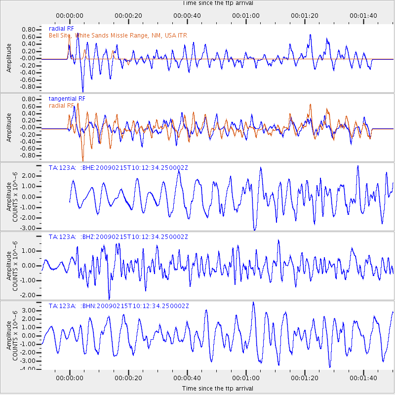
123A Bell Site, White Sands Missle Range, NM, USA - Earthquake Result Viewer
*The percent match for this event was below the threshold and hence no stack was calculated.
| Earthquake location: |
Near Coast Of Northern Peru |
| Earthquake latitude/longitude: |
-5.9/-80.9 |
| Earthquake time(UTC): |
2009/02/15 (046) 10:04:49 GMT |
| Earthquake Depth: |
21 km |
| Earthquake Magnitude: |
5.8 MB, 5.7 MS, 6.1 MW, 6.1 MW |
| Earthquake Catalog/Contributor: |
WHDF/NEIC |
|
| Network: |
TA USArray Transportable Network (new EarthScope stations) |
| Station: |
123A Bell Site, White Sands Missle Range, NM, USA |
| Lat/Lon: |
32.63 N/106.26 W |
| Elevation: |
1206 m |
|
| Distance: |
45.2 deg |
| Az: |
329.395 deg |
| Baz: |
143.11 deg |
| Ray Param: |
$rayparam |
*The percent match for this event was below the threshold and hence was not used in the summary stack. |
|
| Radial Match: |
58.345783 % |
| Radial Bump: |
374 |
| Transverse Match: |
53.182106 % |
| Transverse Bump: |
354 |
| SOD ConfigId: |
2658 |
| Insert Time: |
2010-03-06 10:52:55.851 +0000 |
| GWidth: |
2.5 |
| Max Bumps: |
400 |
| Tol: |
0.001 |
|
Signal To Noise
| Channel | StoN | STA | LTA |
| TA:123A: :BHZ:20090215T10:12:34.250002Z | 2.0100503 | 5.649155E-7 | 2.8104546E-7 |
| TA:123A: :BHN:20090215T10:12:34.250002Z | 0.85056657 | 7.393709E-7 | 8.6926866E-7 |
| TA:123A: :BHE:20090215T10:12:34.250002Z | 1.2967185 | 1.0755483E-6 | 8.294386E-7 |
| Arrivals |
| Ps | |
| PpPs | |
| PsPs/PpSs | |


