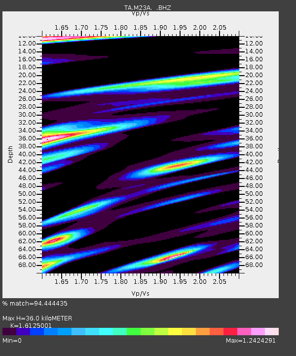
M23A Laramie, WY, USA - Earthquake Result Viewer
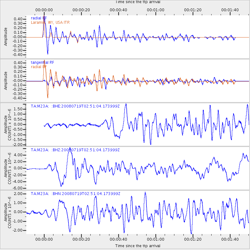
Earthquake location: Off East Coast Of Honshu, Japan
Earthquake latitude/longitude: 37.6/142.2
Earthquake time(UTC): 2008/07/19 (201) 02:39:28 GMT
Earthquake Depth: 22 km
Earthquake Magnitude: 6.2 MB, 7.0 MS, 7.0 MW, 6.9 MW
Earthquake Catalog/Contributor: WHDF/NEIC
Network: TA USArray Transportable Network (new EarthScope stations)
Station: M23A Laramie, WY, USA
Lat/Lon: 41.47 N/105.72 W
Elevation: 2166 m
Distance: 79.9 deg
Az: 45.035 deg
Baz: 311.561 deg
Ray Param: 0.0486476
Estimated Moho Depth: 36.0 km
Estimated Crust Vp/Vs: 1.61
Assumed Crust Vp: 6.306 km/s
Estimated Crust Vs: 3.911 km/s
Estimated Crust Poisson's Ratio: 0.19
Radial Match: 94.444435 %
Radial Bump: 400
Transverse Match: 77.768265 %
Transverse Bump: 400
SOD ConfigId: 2504
Insert Time: 2010-03-06 10:53:07.507 +0000
GWidth: 2.5
Max Bumps: 400
Tol: 0.001

Signal To Noise

ChannelStoNSTALTA
TA:M23A: :BHZ:20080719T02:51:04.173999Z7.38188846.1988425E-78.397367E-8
TA:M23A: :BHN:20080719T02:51:04.173999Z3.72883962.998237E-78.04067E-8
TA:M23A: :BHE:20080719T02:51:04.173999Z2.6341452.583553E-79.807938E-8
Arrivals
Ps3.6 SECOND
PpPs14 SECOND
PsPs/PpSs18 SECOND