You are here: Home > Network List > AK - Alaska Regional Network Stations List
> Station CUT Chulitna, AK, USA > Earthquake Result Viewer
CUT Chulitna, AK, USA - Earthquake Result Viewer
| Earthquake location: |
Hawaii |
| Earthquake latitude/longitude: |
19.4/-155.0 |
| Earthquake time(UTC): |
2018/05/04 (124) 22:32:55 GMT |
| Earthquake Depth: |
5.0 km |
| Earthquake Magnitude: |
5.8 Ml |
| Earthquake Catalog/Contributor: |
NEIC PDE/us |
|
| Network: |
AK Alaska Regional Network |
| Station: |
CUT Chulitna, AK, USA |
| Lat/Lon: |
62.41 N/150.26 W |
| Elevation: |
574 m |
|
| Distance: |
43.1 deg |
| Az: |
3.247 deg |
| Baz: |
186.594 deg |
| Ray Param: |
0.072767034 |
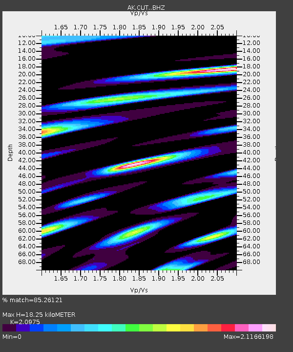
| Estimated Moho Depth: |
18.25 km |
| Estimated Crust Vp/Vs: |
2.10 |
| Assumed Crust Vp: |
6.438 km/s |
| Estimated Crust Vs: |
3.069 km/s |
| Estimated Crust Poisson's Ratio: |
0.35 |
|
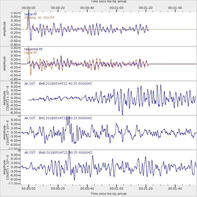
| Radial Match: |
85.26121 % |
| Radial Bump: |
400 |
| Transverse Match: |
74.41123 % |
| Transverse Bump: |
400 |
| SOD ConfigId: |
13570011 |
| Insert Time: |
2019-04-30 04:55:21.444 +0000 |
| GWidth: |
2.5 |
| Max Bumps: |
400 |
| Tol: |
0.001 |
|
Signal To Noise
| Channel | StoN | STA | LTA |
| AK:CUT: :BHZ:20180504T22:40:25.600006Z | 7.0233665 | 2.0121993E-6 | 2.8650066E-7 |
| AK:CUT: :BHN:20180504T22:40:25.600006Z | 2.2109334 | 1.6242477E-6 | 7.3464344E-7 |
| AK:CUT: :BHE:20180504T22:40:25.600006Z | 1.0757358 | 6.2700565E-7 | 5.828621E-7 |
| Arrivals |
| Ps | 3.3 SECOND |
| PpPs | 8.3 SECOND |
| PsPs/PpSs | 12 SECOND |


