You are here: Home > Network List > TA - USArray Transportable Network (new EarthScope stations) Stations List
> Station M23A Laramie, WY, USA > Earthquake Result Viewer
M23A Laramie, WY, USA - Earthquake Result Viewer
| Earthquake location: |
Eastern Honshu, Japan |
| Earthquake latitude/longitude: |
39.8/141.5 |
| Earthquake time(UTC): |
2008/07/23 (205) 15:26:19 GMT |
| Earthquake Depth: |
108 km |
| Earthquake Magnitude: |
6.6 MB, 6.8 MW, 6.8 MW |
| Earthquake Catalog/Contributor: |
WHDF/NEIC |
|
| Network: |
TA USArray Transportable Network (new EarthScope stations) |
| Station: |
M23A Laramie, WY, USA |
| Lat/Lon: |
41.47 N/105.72 W |
| Elevation: |
2166 m |
|
| Distance: |
78.7 deg |
| Az: |
44.947 deg |
| Baz: |
313.6 deg |
| Ray Param: |
0.049225587 |
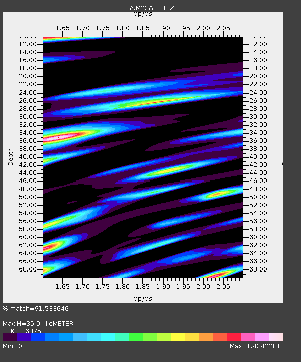
| Estimated Moho Depth: |
35.0 km |
| Estimated Crust Vp/Vs: |
1.64 |
| Assumed Crust Vp: |
6.306 km/s |
| Estimated Crust Vs: |
3.851 km/s |
| Estimated Crust Poisson's Ratio: |
0.20 |
|
| Radial Match: |
91.533646 % |
| Radial Bump: |
400 |
| Transverse Match: |
91.52817 % |
| Transverse Bump: |
384 |
| SOD ConfigId: |
2504 |
| Insert Time: |
2010-03-06 10:53:11.975 +0000 |
| GWidth: |
2.5 |
| Max Bumps: |
400 |
| Tol: |
0.001 |
|

Signal To Noise
| Channel | StoN | STA | LTA |
| TA:M23A: :BHZ:20080723T15:37:39.249011Z | 59.53812 | 6.4546207E-6 | 1.0841156E-7 |
| TA:M23A: :BHN:20080723T15:37:39.249011Z | 13.188286 | 1.0245724E-6 | 7.7688064E-8 |
| TA:M23A: :BHE:20080723T15:37:39.249011Z | 7.705208 | 9.346363E-7 | 1.212993E-7 |
| Arrivals |
| Ps | 3.6 SECOND |
| PpPs | 14 SECOND |
| PsPs/PpSs | 18 SECOND |


