You are here: Home > Network List > TA - USArray Transportable Network (new EarthScope stations) Stations List
> Station M23A Laramie, WY, USA > Earthquake Result Viewer
M23A Laramie, WY, USA - Earthquake Result Viewer
| Earthquake location: |
Kyushu, Japan |
| Earthquake latitude/longitude: |
31.1/130.0 |
| Earthquake time(UTC): |
2009/09/03 (246) 13:26:18 GMT |
| Earthquake Depth: |
166 km |
| Earthquake Magnitude: |
5.9 MB, 6.2 MW, 6.2 MW |
| Earthquake Catalog/Contributor: |
WHDF/NEIC |
|
| Network: |
TA USArray Transportable Network (new EarthScope stations) |
| Station: |
M23A Laramie, WY, USA |
| Lat/Lon: |
41.47 N/105.72 W |
| Elevation: |
2166 m |
|
| Distance: |
91.3 deg |
| Az: |
38.414 deg |
| Baz: |
314.855 deg |
| Ray Param: |
0.041551538 |
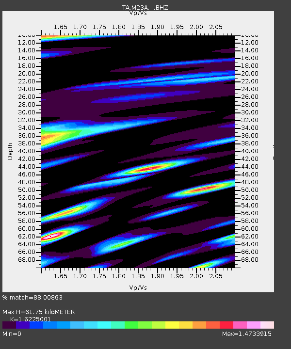
| Estimated Moho Depth: |
61.75 km |
| Estimated Crust Vp/Vs: |
1.62 |
| Assumed Crust Vp: |
6.306 km/s |
| Estimated Crust Vs: |
3.887 km/s |
| Estimated Crust Poisson's Ratio: |
0.19 |
|
| Radial Match: |
88.00863 % |
| Radial Bump: |
371 |
| Transverse Match: |
77.3495 % |
| Transverse Bump: |
400 |
| SOD ConfigId: |
2622 |
| Insert Time: |
2010-03-06 10:53:58.604 +0000 |
| GWidth: |
2.5 |
| Max Bumps: |
400 |
| Tol: |
0.001 |
|

Signal To Noise
| Channel | StoN | STA | LTA |
| TA:M23A: :BHZ:20090903T13:38:33.799021Z | 9.995169 | 8.697162E-7 | 8.701366E-8 |
| TA:M23A: :BHN:20090903T13:38:33.799021Z | 2.475053 | 3.6233521E-7 | 1.4639492E-7 |
| TA:M23A: :BHE:20090903T13:38:33.799021Z | 2.3078957 | 2.2772565E-7 | 9.8672416E-8 |
| Arrivals |
| Ps | 6.2 SECOND |
| PpPs | 25 SECOND |
| PsPs/PpSs | 31 SECOND |


