You are here: Home > Network List > TA - USArray Transportable Network (new EarthScope stations) Stations List
> Station M23A Laramie, WY, USA > Earthquake Result Viewer
M23A Laramie, WY, USA - Earthquake Result Viewer
| Earthquake location: |
Hokkaido, Japan Region |
| Earthquake latitude/longitude: |
41.8/143.4 |
| Earthquake time(UTC): |
2009/06/05 (156) 03:30:33 GMT |
| Earthquake Depth: |
29 km |
| Earthquake Magnitude: |
6.0 MB, 6.3 MS, 6.4 MW, 6.4 MW |
| Earthquake Catalog/Contributor: |
WHDF/NEIC |
|
| Network: |
TA USArray Transportable Network (new EarthScope stations) |
| Station: |
M23A Laramie, WY, USA |
| Lat/Lon: |
41.47 N/105.72 W |
| Elevation: |
2166 m |
|
| Distance: |
76.2 deg |
| Az: |
46.325 deg |
| Baz: |
314.002 deg |
| Ray Param: |
0.051115006 |
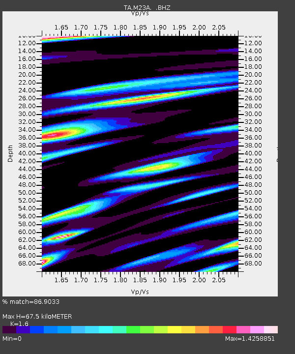
| Estimated Moho Depth: |
67.5 km |
| Estimated Crust Vp/Vs: |
1.60 |
| Assumed Crust Vp: |
6.306 km/s |
| Estimated Crust Vs: |
3.941 km/s |
| Estimated Crust Poisson's Ratio: |
0.18 |
|
| Radial Match: |
86.9033 % |
| Radial Bump: |
400 |
| Transverse Match: |
72.55702 % |
| Transverse Bump: |
400 |
| SOD ConfigId: |
2648 |
| Insert Time: |
2010-03-06 10:54:09.495 +0000 |
| GWidth: |
2.5 |
| Max Bumps: |
400 |
| Tol: |
0.001 |
|
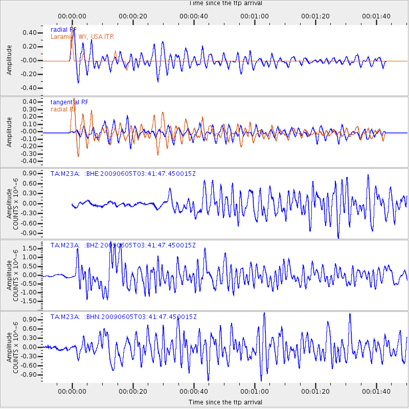
Signal To Noise
| Channel | StoN | STA | LTA |
| TA:M23A: :BHZ:20090605T03:41:47.450015Z | 11.802106 | 5.836536E-7 | 4.9453348E-8 |
| TA:M23A: :BHN:20090605T03:41:47.450015Z | 3.0583677 | 1.7824486E-7 | 5.8281042E-8 |
| TA:M23A: :BHE:20090605T03:41:47.450015Z | 3.7411177 | 1.8970911E-7 | 5.0709207E-8 |
| Arrivals |
| Ps | 6.6 SECOND |
| PpPs | 27 SECOND |
| PsPs/PpSs | 34 SECOND |


