You are here: Home > Network List > N4 - Central and EAstern US Network Stations List
> Station 735B Kenedy, TX, USA > Earthquake Result Viewer
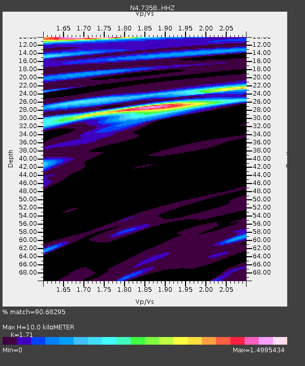
735B Kenedy, TX, USA - Earthquake Result Viewer
| Earthquake location: |
Hawaii |
| Earthquake latitude/longitude: |
19.4/-155.0 |
| Earthquake time(UTC): |
2018/05/04 (124) 22:32:55 GMT |
| Earthquake Depth: |
5.0 km |
| Earthquake Magnitude: |
5.8 Ml |
| Earthquake Catalog/Contributor: |
NEIC PDE/us |
|
| Network: |
N4 Central and EAstern US Network |
| Station: |
735B Kenedy, TX, USA |
| Lat/Lon: |
28.86 N/97.81 W |
| Elevation: |
109 m |
|
| Distance: |
52.7 deg |
| Az: |
68.086 deg |
| Baz: |
273.16 deg |
| Ray Param: |
0.066633075 |
| Estimated Moho Depth: |
10.0 km |
| Estimated Crust Vp/Vs: |
1.71 |
| Assumed Crust Vp: |
5.78 km/s |
| Estimated Crust Vs: |
3.38 km/s |
| Estimated Crust Poisson's Ratio: |
0.24 |
|
| Radial Match: |
90.68295 % |
| Radial Bump: |
387 |
| Transverse Match: |
83.24655 % |
| Transverse Bump: |
400 |
| SOD ConfigId: |
13570011 |
| Insert Time: |
2019-04-30 04:59:57.448 +0000 |
| GWidth: |
2.5 |
| Max Bumps: |
400 |
| Tol: |
0.001 |
|

Signal To Noise
| Channel | StoN | STA | LTA |
| N4:735B: :HHZ:20180504T22:41:38.809998Z | 2.9432464 | 9.028682E-7 | 3.067593E-7 |
| N4:735B: :HHN:20180504T22:41:38.809998Z | 2.2777224 | 8.461999E-7 | 3.7151142E-7 |
| N4:735B: :HHE:20180504T22:41:38.809998Z | 0.84804606 | 3.9070565E-7 | 4.6071278E-7 |
| Arrivals |
| Ps | 1.3 SECOND |
| PpPs | 4.5 SECOND |
| PsPs/PpSs | 5.8 SECOND |


