You are here: Home > Network List > TA - USArray Transportable Network (new EarthScope stations) Stations List
> Station M23A Laramie, WY, USA > Earthquake Result Viewer
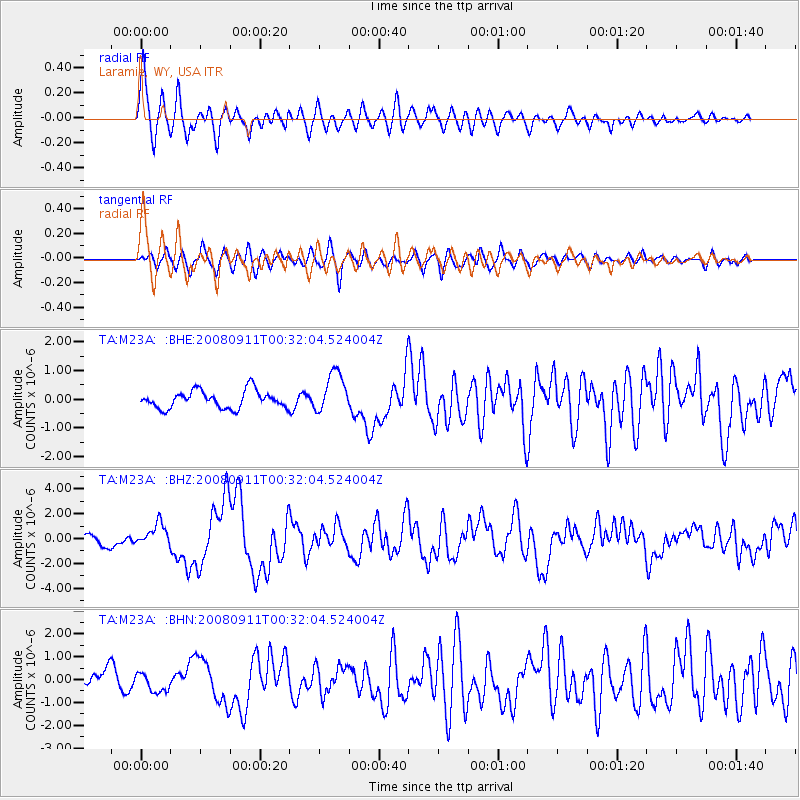
M23A Laramie, WY, USA - Earthquake Result Viewer
*The percent match for this event was below the threshold and hence no stack was calculated.
| Earthquake location: |
Hokkaido, Japan Region |
| Earthquake latitude/longitude: |
41.9/143.8 |
| Earthquake time(UTC): |
2008/09/11 (255) 00:20:50 GMT |
| Earthquake Depth: |
25 km |
| Earthquake Magnitude: |
6.1 MB, 7.0 MS, 6.8 MW, 6.8 MW |
| Earthquake Catalog/Contributor: |
WHDF/NEIC |
|
| Network: |
TA USArray Transportable Network (new EarthScope stations) |
| Station: |
M23A Laramie, WY, USA |
| Lat/Lon: |
41.47 N/105.72 W |
| Elevation: |
2166 m |
|
| Distance: |
76.0 deg |
| Az: |
46.503 deg |
| Baz: |
313.889 deg |
| Ray Param: |
$rayparam |
*The percent match for this event was below the threshold and hence was not used in the summary stack. |
|
| Radial Match: |
79.38542 % |
| Radial Bump: |
400 |
| Transverse Match: |
75.90318 % |
| Transverse Bump: |
400 |
| SOD ConfigId: |
2560 |
| Insert Time: |
2010-03-06 10:54:53.652 +0000 |
| GWidth: |
2.5 |
| Max Bumps: |
400 |
| Tol: |
0.001 |
|
Signal To Noise
| Channel | StoN | STA | LTA |
| TA:M23A: :BHZ:20080911T00:32:04.524004Z | 2.482981 | 9.074463E-7 | 3.6546646E-7 |
| TA:M23A: :BHN:20080911T00:32:04.524004Z | 0.9809494 | 4.0865962E-7 | 4.1659604E-7 |
| TA:M23A: :BHE:20080911T00:32:04.524004Z | 2.3192804 | 7.0384993E-7 | 3.0347772E-7 |
| Arrivals |
| Ps | |
| PpPs | |
| PsPs/PpSs | |


