You are here: Home > Network List > N4 - Central and EAstern US Network Stations List
> Station R55A Marlinton, WV, USA > Earthquake Result Viewer
R55A Marlinton, WV, USA - Earthquake Result Viewer
| Earthquake location: |
Hawaii |
| Earthquake latitude/longitude: |
19.4/-155.0 |
| Earthquake time(UTC): |
2018/05/04 (124) 22:32:55 GMT |
| Earthquake Depth: |
5.0 km |
| Earthquake Magnitude: |
5.8 Ml |
| Earthquake Catalog/Contributor: |
NEIC PDE/us |
|
| Network: |
N4 Central and EAstern US Network |
| Station: |
R55A Marlinton, WV, USA |
| Lat/Lon: |
38.28 N/80.12 W |
| Elevation: |
833 m |
|
| Distance: |
66.6 deg |
| Az: |
55.875 deg |
| Baz: |
276.747 deg |
| Ray Param: |
0.05750544 |
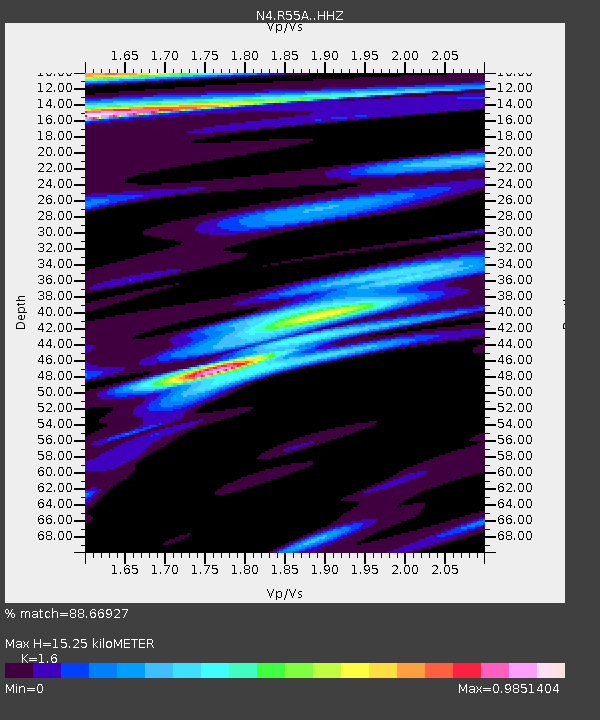
| Estimated Moho Depth: |
15.25 km |
| Estimated Crust Vp/Vs: |
1.60 |
| Assumed Crust Vp: |
6.207 km/s |
| Estimated Crust Vs: |
3.879 km/s |
| Estimated Crust Poisson's Ratio: |
0.18 |
|
| Radial Match: |
88.66927 % |
| Radial Bump: |
400 |
| Transverse Match: |
76.36428 % |
| Transverse Bump: |
400 |
| SOD ConfigId: |
13570011 |
| Insert Time: |
2019-04-30 05:00:33.547 +0000 |
| GWidth: |
2.5 |
| Max Bumps: |
400 |
| Tol: |
0.001 |
|

Signal To Noise
| Channel | StoN | STA | LTA |
| N4:R55A: :HHZ:20180504T22:43:15.02002Z | 2.7928352 | 4.1446992E-7 | 1.4840472E-7 |
| N4:R55A: :HHN:20180504T22:43:15.02002Z | 1.2706795 | 1.2532598E-7 | 9.86291E-8 |
| N4:R55A: :HHE:20180504T22:43:15.02002Z | 1.0561341 | 1.2123029E-7 | 1.1478683E-7 |
| Arrivals |
| Ps | 1.5 SECOND |
| PpPs | 6.1 SECOND |
| PsPs/PpSs | 7.7 SECOND |


