You are here: Home > Network List > N4 - Central and EAstern US Network Stations List
> Station Y58A Scranton, SC, USA > Earthquake Result Viewer
Y58A Scranton, SC, USA - Earthquake Result Viewer
| Earthquake location: |
Hawaii |
| Earthquake latitude/longitude: |
19.4/-155.0 |
| Earthquake time(UTC): |
2018/05/04 (124) 22:32:55 GMT |
| Earthquake Depth: |
5.0 km |
| Earthquake Magnitude: |
5.8 Ml |
| Earthquake Catalog/Contributor: |
NEIC PDE/us |
|
| Network: |
N4 Central and EAstern US Network |
| Station: |
Y58A Scranton, SC, USA |
| Lat/Lon: |
33.91 N/79.67 W |
| Elevation: |
19 m |
|
| Distance: |
67.6 deg |
| Az: |
60.519 deg |
| Baz: |
278.821 deg |
| Ray Param: |
0.05687594 |
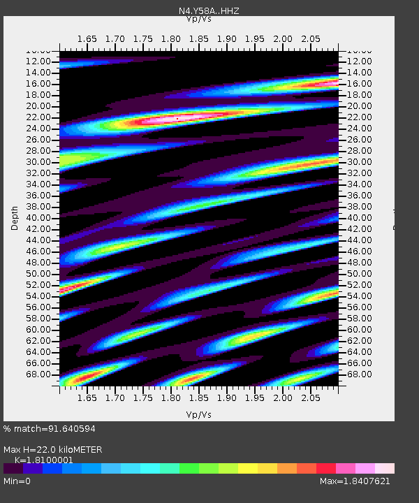
| Estimated Moho Depth: |
22.0 km |
| Estimated Crust Vp/Vs: |
1.81 |
| Assumed Crust Vp: |
6.24 km/s |
| Estimated Crust Vs: |
3.448 km/s |
| Estimated Crust Poisson's Ratio: |
0.28 |
|
| Radial Match: |
91.640594 % |
| Radial Bump: |
400 |
| Transverse Match: |
71.18495 % |
| Transverse Bump: |
400 |
| SOD ConfigId: |
13570011 |
| Insert Time: |
2019-04-30 05:00:54.604 +0000 |
| GWidth: |
2.5 |
| Max Bumps: |
400 |
| Tol: |
0.001 |
|

Signal To Noise
| Channel | StoN | STA | LTA |
| N4:Y58A: :HHZ:20180504T22:43:21.039978Z | 3.2630932 | 4.9513164E-7 | 1.517369E-7 |
| N4:Y58A: :HHN:20180504T22:43:21.039978Z | 0.95319295 | 2.5492724E-7 | 2.6744556E-7 |
| N4:Y58A: :HHE:20180504T22:43:21.039978Z | 1.5830624 | 3.3866263E-7 | 2.1392879E-7 |
| Arrivals |
| Ps | 3.0 SECOND |
| PpPs | 9.6 SECOND |
| PsPs/PpSs | 13 SECOND |


