You are here: Home > Network List > US - United States National Seismic Network Stations List
> Station ELK Elko, Nevada, USA > Earthquake Result Viewer
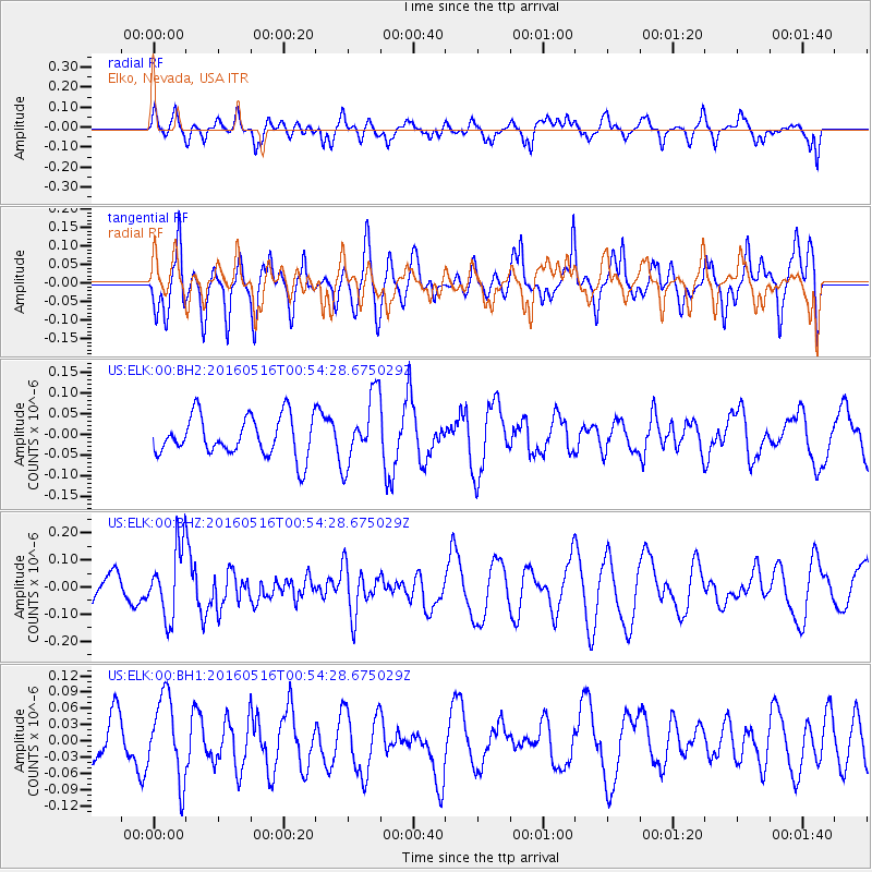
ELK Elko, Nevada, USA - Earthquake Result Viewer
*The percent match for this event was below the threshold and hence no stack was calculated.
| Earthquake location: |
Southeast Of Loyalty Islands |
| Earthquake latitude/longitude: |
-22.5/173.0 |
| Earthquake time(UTC): |
2016/05/16 (137) 00:41:53 GMT |
| Earthquake Depth: |
10 km |
| Earthquake Magnitude: |
5.8 MWW, 5.7 MWB, 5.8 MWC |
| Earthquake Catalog/Contributor: |
NEIC PDE/NEIC COMCAT |
|
| Network: |
US United States National Seismic Network |
| Station: |
ELK Elko, Nevada, USA |
| Lat/Lon: |
40.74 N/115.24 W |
| Elevation: |
2210 m |
|
| Distance: |
91.6 deg |
| Az: |
46.215 deg |
| Baz: |
241.476 deg |
| Ray Param: |
$rayparam |
*The percent match for this event was below the threshold and hence was not used in the summary stack. |
|
| Radial Match: |
45.578808 % |
| Radial Bump: |
400 |
| Transverse Match: |
50.83947 % |
| Transverse Bump: |
400 |
| SOD ConfigId: |
1475611 |
| Insert Time: |
2016-05-30 00:45:02.323 +0000 |
| GWidth: |
2.5 |
| Max Bumps: |
400 |
| Tol: |
0.001 |
|
Signal To Noise
| Channel | StoN | STA | LTA |
| US:ELK:00:BHZ:20160516T00:54:28.675029Z | 2.1732335 | 1.3097984E-7 | 6.0269564E-8 |
| US:ELK:00:BH1:20160516T00:54:28.675029Z | 1.5728115 | 7.558721E-8 | 4.805866E-8 |
| US:ELK:00:BH2:20160516T00:54:28.675029Z | 1.7360874 | 8.26132E-8 | 4.758585E-8 |
| Arrivals |
| Ps | |
| PpPs | |
| PsPs/PpSs | |


