You are here: Home > Network List > PE - Penn State Network Stations List
> Station PABK Blue Knob State Park, Imler, PA > Earthquake Result Viewer
PABK Blue Knob State Park, Imler, PA - Earthquake Result Viewer
| Earthquake location: |
Hawaii |
| Earthquake latitude/longitude: |
19.4/-155.0 |
| Earthquake time(UTC): |
2018/05/04 (124) 22:32:55 GMT |
| Earthquake Depth: |
5.0 km |
| Earthquake Magnitude: |
5.8 Ml |
| Earthquake Catalog/Contributor: |
NEIC PDE/us |
|
| Network: |
PE Penn State Network |
| Station: |
PABK Blue Knob State Park, Imler, PA |
| Lat/Lon: |
40.27 N/78.58 W |
| Elevation: |
482 m |
|
| Distance: |
67.6 deg |
| Az: |
53.587 deg |
| Baz: |
276.825 deg |
| Ray Param: |
0.056879815 |
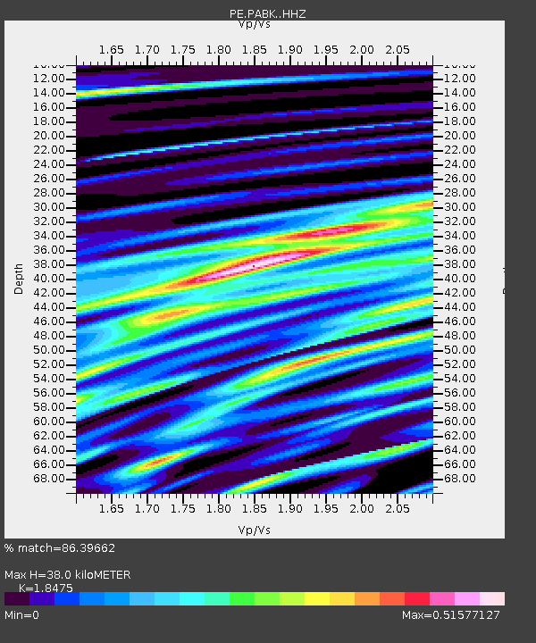
| Estimated Moho Depth: |
38.0 km |
| Estimated Crust Vp/Vs: |
1.85 |
| Assumed Crust Vp: |
6.121 km/s |
| Estimated Crust Vs: |
3.313 km/s |
| Estimated Crust Poisson's Ratio: |
0.29 |
|
| Radial Match: |
86.39662 % |
| Radial Bump: |
400 |
| Transverse Match: |
77.1761 % |
| Transverse Bump: |
400 |
| SOD ConfigId: |
13570011 |
| Insert Time: |
2019-04-30 05:02:01.280 +0000 |
| GWidth: |
2.5 |
| Max Bumps: |
400 |
| Tol: |
0.001 |
|

Signal To Noise
| Channel | StoN | STA | LTA |
| PE:PABK: :HHZ:20180504T22:43:21.049988Z | 2.863667 | 1.6840934E-6 | 5.880898E-7 |
| PE:PABK: :HHN:20180504T22:43:21.049988Z | 2.326189 | 9.1151736E-7 | 3.9185008E-7 |
| PE:PABK: :HHE:20180504T22:43:21.049988Z | 1.6934482 | 1.0956751E-6 | 6.4700833E-7 |
| Arrivals |
| Ps | 5.4 SECOND |
| PpPs | 17 SECOND |
| PsPs/PpSs | 23 SECOND |


