You are here: Home > Network List > TA - USArray Transportable Network (new EarthScope stations) Stations List
> Station C23K Itkillik River, AK, USA > Earthquake Result Viewer
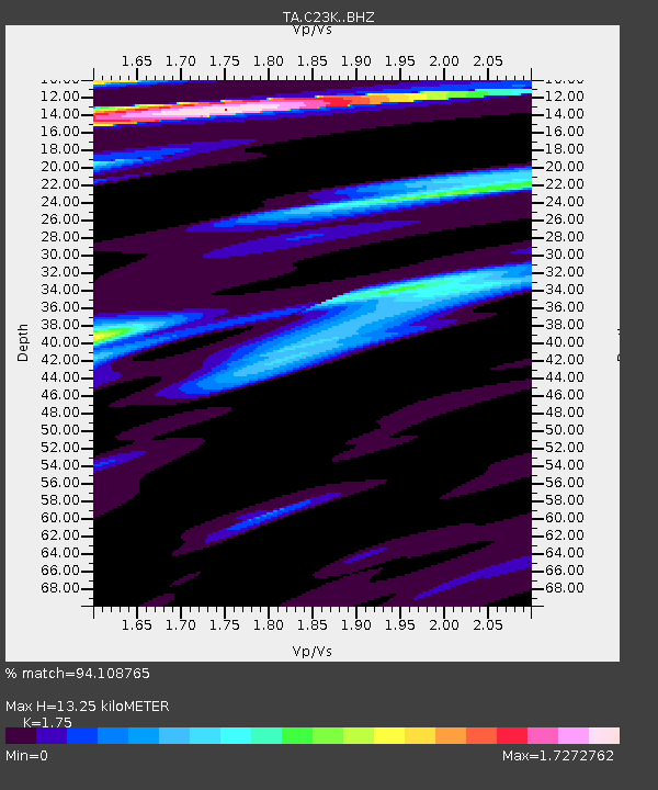
C23K Itkillik River, AK, USA - Earthquake Result Viewer
| Earthquake location: |
Hawaii |
| Earthquake latitude/longitude: |
19.4/-155.0 |
| Earthquake time(UTC): |
2018/05/04 (124) 22:32:55 GMT |
| Earthquake Depth: |
5.0 km |
| Earthquake Magnitude: |
5.8 Ml |
| Earthquake Catalog/Contributor: |
NEIC PDE/us |
|
| Network: |
TA USArray Transportable Network (new EarthScope stations) |
| Station: |
C23K Itkillik River, AK, USA |
| Lat/Lon: |
69.84 N/150.61 W |
| Elevation: |
179 m |
|
| Distance: |
50.5 deg |
| Az: |
1.984 deg |
| Baz: |
185.407 deg |
| Ray Param: |
0.06800635 |
| Estimated Moho Depth: |
13.25 km |
| Estimated Crust Vp/Vs: |
1.75 |
| Assumed Crust Vp: |
6.221 km/s |
| Estimated Crust Vs: |
3.555 km/s |
| Estimated Crust Poisson's Ratio: |
0.26 |
|
| Radial Match: |
94.108765 % |
| Radial Bump: |
400 |
| Transverse Match: |
71.91797 % |
| Transverse Bump: |
400 |
| SOD ConfigId: |
13570011 |
| Insert Time: |
2019-04-30 05:03:11.921 +0000 |
| GWidth: |
2.5 |
| Max Bumps: |
400 |
| Tol: |
0.001 |
|

Signal To Noise
| Channel | StoN | STA | LTA |
| TA:C23K: :BHZ:20180504T22:41:23.475006Z | 6.553537 | 1.9549348E-6 | 2.983022E-7 |
| TA:C23K: :BHN:20180504T22:41:23.475006Z | 2.6275432 | 7.3363987E-7 | 2.7921132E-7 |
| TA:C23K: :BHE:20180504T22:41:23.475006Z | 0.71461624 | 3.0470622E-7 | 4.263914E-7 |
| Arrivals |
| Ps | 1.7 SECOND |
| PpPs | 5.5 SECOND |
| PsPs/PpSs | 7.2 SECOND |


