You are here: Home > Network List > TA - USArray Transportable Network (new EarthScope stations) Stations List
> Station D28M Stokes Point, YT, CAN > Earthquake Result Viewer
D28M Stokes Point, YT, CAN - Earthquake Result Viewer
| Earthquake location: |
Hawaii |
| Earthquake latitude/longitude: |
19.4/-155.0 |
| Earthquake time(UTC): |
2018/05/04 (124) 22:32:55 GMT |
| Earthquake Depth: |
5.0 km |
| Earthquake Magnitude: |
5.8 Ml |
| Earthquake Catalog/Contributor: |
NEIC PDE/us |
|
| Network: |
TA USArray Transportable Network (new EarthScope stations) |
| Station: |
D28M Stokes Point, YT, CAN |
| Lat/Lon: |
69.33 N/138.74 W |
| Elevation: |
32 m |
|
| Distance: |
51.0 deg |
| Az: |
7.371 deg |
| Baz: |
199.944 deg |
| Ray Param: |
0.067729846 |
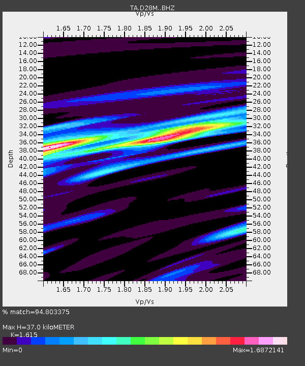
| Estimated Moho Depth: |
37.0 km |
| Estimated Crust Vp/Vs: |
1.62 |
| Assumed Crust Vp: |
6.316 km/s |
| Estimated Crust Vs: |
3.911 km/s |
| Estimated Crust Poisson's Ratio: |
0.19 |
|
| Radial Match: |
94.803375 % |
| Radial Bump: |
400 |
| Transverse Match: |
83.49765 % |
| Transverse Bump: |
400 |
| SOD ConfigId: |
13570011 |
| Insert Time: |
2019-04-30 05:03:22.798 +0000 |
| GWidth: |
2.5 |
| Max Bumps: |
400 |
| Tol: |
0.001 |
|

Signal To Noise
| Channel | StoN | STA | LTA |
| TA:D28M: :BHZ:20180504T22:41:26.600006Z | 6.9143558 | 1.3894085E-6 | 2.0094546E-7 |
| TA:D28M: :BHN:20180504T22:41:26.600006Z | 4.0242314 | 5.209865E-7 | 1.2946235E-7 |
| TA:D28M: :BHE:20180504T22:41:26.600006Z | 1.3959761 | 2.838998E-7 | 2.0337009E-7 |
| Arrivals |
| Ps | 3.8 SECOND |
| PpPs | 14 SECOND |
| PsPs/PpSs | 18 SECOND |


