You are here: Home > Network List > TA - USArray Transportable Network (new EarthScope stations) Stations List
> Station M23A Laramie, WY, USA > Earthquake Result Viewer
M23A Laramie, WY, USA - Earthquake Result Viewer
*The percent match for this event was below the threshold and hence no stack was calculated.
| Earthquake location: |
Eastern Kazakhstan |
| Earthquake latitude/longitude: |
44.7/78.9 |
| Earthquake time(UTC): |
2009/06/13 (164) 17:17:38 GMT |
| Earthquake Depth: |
14 km |
| Earthquake Magnitude: |
5.8 MB, 5.1 MS, 5.4 MW, 5.4 MW |
| Earthquake Catalog/Contributor: |
WHDF/NEIC |
|
| Network: |
TA USArray Transportable Network (new EarthScope stations) |
| Station: |
M23A Laramie, WY, USA |
| Lat/Lon: |
41.47 N/105.72 W |
| Elevation: |
2166 m |
|
| Distance: |
94.1 deg |
| Az: |
3.454 deg |
| Baz: |
356.724 deg |
| Ray Param: |
$rayparam |
*The percent match for this event was below the threshold and hence was not used in the summary stack. |
|
| Radial Match: |
58.683407 % |
| Radial Bump: |
400 |
| Transverse Match: |
66.14879 % |
| Transverse Bump: |
400 |
| SOD ConfigId: |
2648 |
| Insert Time: |
2010-03-06 10:55:43.104 +0000 |
| GWidth: |
2.5 |
| Max Bumps: |
400 |
| Tol: |
0.001 |
|
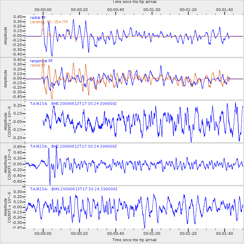
Signal To Noise
| Channel | StoN | STA | LTA |
| TA:M23A: :BHZ:20090613T17:30:24.399009Z | 3.8169034 | 2.412689E-7 | 6.321064E-8 |
| TA:M23A: :BHN:20090613T17:30:24.399009Z | 1.2398031 | 8.6938485E-8 | 7.0122816E-8 |
| TA:M23A: :BHE:20090613T17:30:24.399009Z | 0.836065 | 5.7933164E-8 | 6.929266E-8 |
| Arrivals |
| Ps | |
| PpPs | |
| PsPs/PpSs | |


