You are here: Home > Network List > TA - USArray Transportable Network (new EarthScope stations) Stations List
> Station G30M t˙h Zraii Njik, YT, CAN > Earthquake Result Viewer
G30M t˙h Zraii Njik, YT, CAN - Earthquake Result Viewer
| Earthquake location: |
Hawaii |
| Earthquake latitude/longitude: |
19.4/-155.0 |
| Earthquake time(UTC): |
2018/05/04 (124) 22:32:55 GMT |
| Earthquake Depth: |
5.0 km |
| Earthquake Magnitude: |
5.8 Ml |
| Earthquake Catalog/Contributor: |
NEIC PDE/us |
|
| Network: |
TA USArray Transportable Network (new EarthScope stations) |
| Station: |
G30M t˙h Zraii Njik, YT, CAN |
| Lat/Lon: |
66.98 N/136.22 W |
| Elevation: |
739 m |
|
| Distance: |
49.1 deg |
| Az: |
9.656 deg |
| Baz: |
203.745 deg |
| Ray Param: |
0.068924315 |
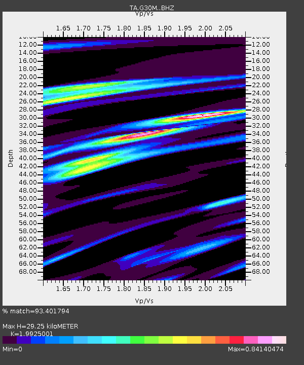
| Estimated Moho Depth: |
29.25 km |
| Estimated Crust Vp/Vs: |
1.99 |
| Assumed Crust Vp: |
6.522 km/s |
| Estimated Crust Vs: |
3.273 km/s |
| Estimated Crust Poisson's Ratio: |
0.33 |
|
| Radial Match: |
93.401794 % |
| Radial Bump: |
400 |
| Transverse Match: |
91.65267 % |
| Transverse Bump: |
400 |
| SOD ConfigId: |
13570011 |
| Insert Time: |
2019-04-30 05:03:53.134 +0000 |
| GWidth: |
2.5 |
| Max Bumps: |
400 |
| Tol: |
0.001 |
|

Signal To Noise
| Channel | StoN | STA | LTA |
| TA:G30M: :BHZ:20180504T22:41:12.649994Z | 7.559269 | 1.3070597E-6 | 1.7290823E-7 |
| TA:G30M: :BHN:20180504T22:41:12.649994Z | 3.9381227 | 4.5916346E-7 | 1.165945E-7 |
| TA:G30M: :BHE:20180504T22:41:12.649994Z | 2.0816455 | 2.4788235E-7 | 1.19080006E-7 |
| Arrivals |
| Ps | 4.7 SECOND |
| PpPs | 13 SECOND |
| PsPs/PpSs | 17 SECOND |


