You are here: Home > Network List > TA - USArray Transportable Network (new EarthScope stations) Stations List
> Station H17K Granite Mountain, AK, USA > Earthquake Result Viewer
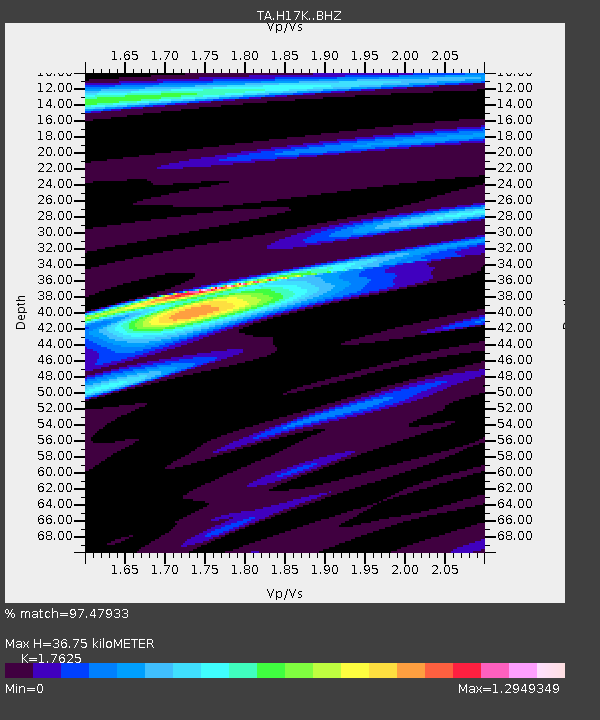
H17K Granite Mountain, AK, USA - Earthquake Result Viewer
| Earthquake location: |
Hawaii |
| Earthquake latitude/longitude: |
19.4/-155.0 |
| Earthquake time(UTC): |
2018/05/04 (124) 22:32:55 GMT |
| Earthquake Depth: |
5.0 km |
| Earthquake Magnitude: |
5.8 Ml |
| Earthquake Catalog/Contributor: |
NEIC PDE/us |
|
| Network: |
TA USArray Transportable Network (new EarthScope stations) |
| Station: |
H17K Granite Mountain, AK, USA |
| Lat/Lon: |
64.94 N/159.91 W |
| Elevation: |
396 m |
|
| Distance: |
45.7 deg |
| Az: |
357.095 deg |
| Baz: |
173.551 deg |
| Ray Param: |
0.07114782 |
| Estimated Moho Depth: |
36.75 km |
| Estimated Crust Vp/Vs: |
1.76 |
| Assumed Crust Vp: |
6.1 km/s |
| Estimated Crust Vs: |
3.461 km/s |
| Estimated Crust Poisson's Ratio: |
0.26 |
|
| Radial Match: |
97.47933 % |
| Radial Bump: |
359 |
| Transverse Match: |
78.5478 % |
| Transverse Bump: |
400 |
| SOD ConfigId: |
13570011 |
| Insert Time: |
2019-04-30 05:03:55.225 +0000 |
| GWidth: |
2.5 |
| Max Bumps: |
400 |
| Tol: |
0.001 |
|

Signal To Noise
| Channel | StoN | STA | LTA |
| TA:H17K: :BHZ:20180504T22:40:45.850006Z | 7.396087 | 1.533519E-6 | 2.0734194E-7 |
| TA:H17K: :BHN:20180504T22:40:45.850006Z | 3.3995783 | 6.390212E-7 | 1.8797073E-7 |
| TA:H17K: :BHE:20180504T22:40:45.850006Z | 0.56335455 | 8.832152E-8 | 1.5677786E-7 |
| Arrivals |
| Ps | 4.9 SECOND |
| PpPs | 16 SECOND |
| PsPs/PpSs | 21 SECOND |


