You are here: Home > Network List > TA - USArray Transportable Network (new EarthScope stations) Stations List
> Station K24K Donnelly Dome, AK, USA > Earthquake Result Viewer
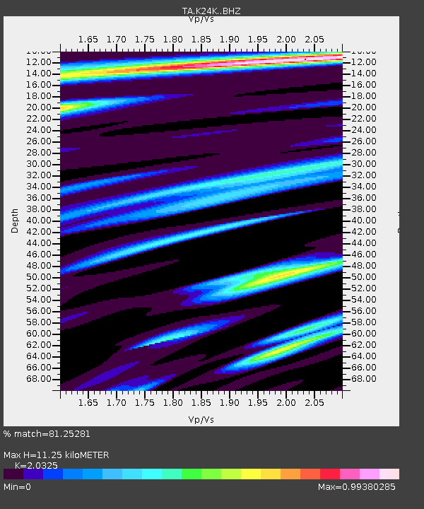
K24K Donnelly Dome, AK, USA - Earthquake Result Viewer
| Earthquake location: |
Hawaii |
| Earthquake latitude/longitude: |
19.4/-155.0 |
| Earthquake time(UTC): |
2018/05/04 (124) 22:32:55 GMT |
| Earthquake Depth: |
5.0 km |
| Earthquake Magnitude: |
5.8 Ml |
| Earthquake Catalog/Contributor: |
NEIC PDE/us |
|
| Network: |
TA USArray Transportable Network (new EarthScope stations) |
| Station: |
K24K Donnelly Dome, AK, USA |
| Lat/Lon: |
63.80 N/145.78 W |
| Elevation: |
724 m |
|
| Distance: |
44.8 deg |
| Az: |
5.809 deg |
| Baz: |
192.432 deg |
| Ray Param: |
0.071678385 |
| Estimated Moho Depth: |
11.25 km |
| Estimated Crust Vp/Vs: |
2.03 |
| Assumed Crust Vp: |
6.566 km/s |
| Estimated Crust Vs: |
3.231 km/s |
| Estimated Crust Poisson's Ratio: |
0.34 |
|
| Radial Match: |
81.25281 % |
| Radial Bump: |
400 |
| Transverse Match: |
61.092228 % |
| Transverse Bump: |
400 |
| SOD ConfigId: |
13570011 |
| Insert Time: |
2019-04-30 05:04:22.462 +0000 |
| GWidth: |
2.5 |
| Max Bumps: |
400 |
| Tol: |
0.001 |
|

Signal To Noise
| Channel | StoN | STA | LTA |
| TA:K24K: :BHZ:20180504T22:40:39.375Z | 3.3734095 | 1.4260073E-6 | 4.2271986E-7 |
| TA:K24K: :BHN:20180504T22:40:39.375Z | 3.122316 | 8.7094793E-7 | 2.7894293E-7 |
| TA:K24K: :BHE:20180504T22:40:39.375Z | 0.9066336 | 6.4545424E-7 | 7.1192403E-7 |
| Arrivals |
| Ps | 1.9 SECOND |
| PpPs | 4.9 SECOND |
| PsPs/PpSs | 6.8 SECOND |


