You are here: Home > Network List > TA - USArray Transportable Network (new EarthScope stations) Stations List
> Station M14K Bethel, AK, USA > Earthquake Result Viewer
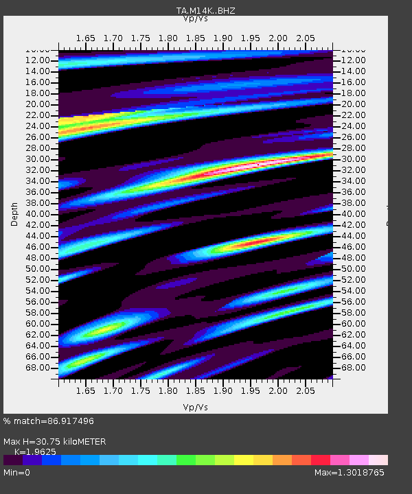
M14K Bethel, AK, USA - Earthquake Result Viewer
| Earthquake location: |
Hawaii |
| Earthquake latitude/longitude: |
19.4/-155.0 |
| Earthquake time(UTC): |
2018/05/04 (124) 22:32:55 GMT |
| Earthquake Depth: |
5.0 km |
| Earthquake Magnitude: |
5.8 Ml |
| Earthquake Catalog/Contributor: |
NEIC PDE/us |
|
| Network: |
TA USArray Transportable Network (new EarthScope stations) |
| Station: |
M14K Bethel, AK, USA |
| Lat/Lon: |
60.75 N/161.96 W |
| Elevation: |
19 m |
|
| Distance: |
41.6 deg |
| Az: |
354.884 deg |
| Baz: |
170.13 deg |
| Ray Param: |
0.073684745 |
| Estimated Moho Depth: |
30.75 km |
| Estimated Crust Vp/Vs: |
1.96 |
| Assumed Crust Vp: |
6.182 km/s |
| Estimated Crust Vs: |
3.15 km/s |
| Estimated Crust Poisson's Ratio: |
0.32 |
|
| Radial Match: |
86.917496 % |
| Radial Bump: |
400 |
| Transverse Match: |
63.530125 % |
| Transverse Bump: |
400 |
| SOD ConfigId: |
13570011 |
| Insert Time: |
2019-04-30 05:04:35.072 +0000 |
| GWidth: |
2.5 |
| Max Bumps: |
400 |
| Tol: |
0.001 |
|

Signal To Noise
| Channel | StoN | STA | LTA |
| TA:M14K: :BHZ:20180504T22:40:13.500Z | 4.401709 | 2.2375175E-6 | 5.0832926E-7 |
| TA:M14K: :BHN:20180504T22:40:13.500Z | 2.6755085 | 1.5242044E-6 | 5.6968776E-7 |
| TA:M14K: :BHE:20180504T22:40:13.500Z | 1.1406618 | 7.4359554E-7 | 6.518983E-7 |
| Arrivals |
| Ps | 5.1 SECOND |
| PpPs | 14 SECOND |
| PsPs/PpSs | 19 SECOND |


