You are here: Home > Network List > TA - USArray Transportable Network (new EarthScope stations) Stations List
> Station MSTX Muleshoe, TX, USA > Earthquake Result Viewer
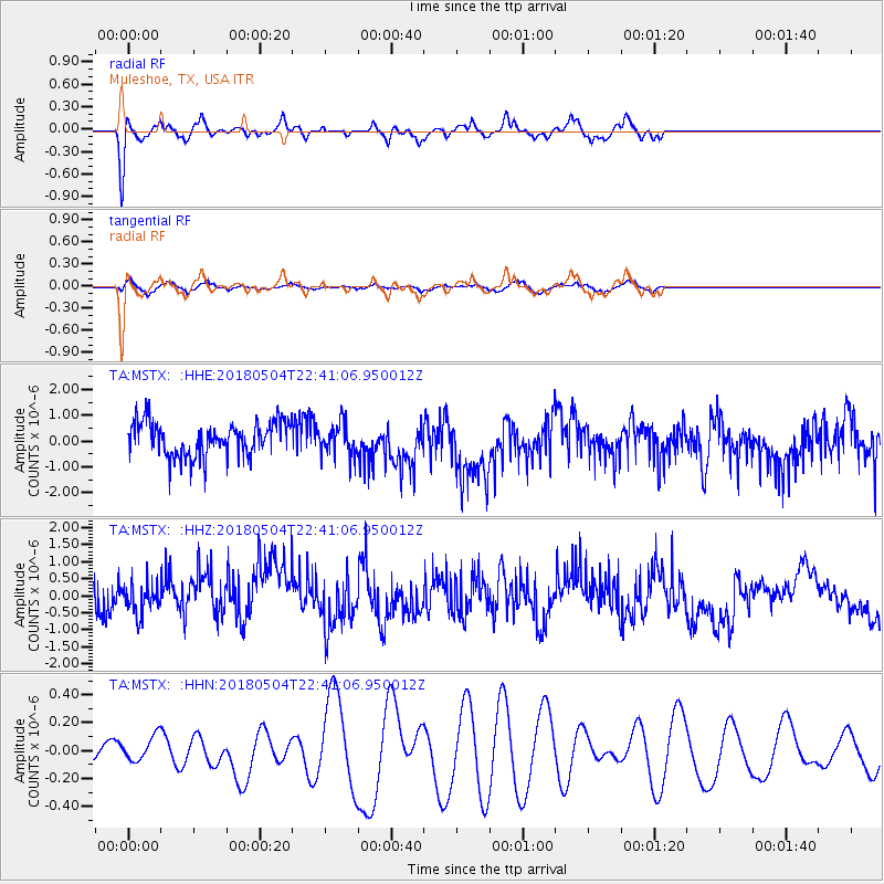
MSTX Muleshoe, TX, USA - Earthquake Result Viewer
*The percent match for this event was below the threshold and hence no stack was calculated.
| Earthquake location: |
Hawaii |
| Earthquake latitude/longitude: |
19.4/-155.0 |
| Earthquake time(UTC): |
2018/05/04 (124) 22:32:55 GMT |
| Earthquake Depth: |
5.0 km |
| Earthquake Magnitude: |
5.8 Ml |
| Earthquake Catalog/Contributor: |
NEIC PDE/us |
|
| Network: |
TA USArray Transportable Network (new EarthScope stations) |
| Station: |
MSTX Muleshoe, TX, USA |
| Lat/Lon: |
33.97 N/102.77 W |
| Elevation: |
1167 m |
|
| Distance: |
48.4 deg |
| Az: |
61.464 deg |
| Baz: |
266.368 deg |
| Ray Param: |
$rayparam |
*The percent match for this event was below the threshold and hence was not used in the summary stack. |
|
| Radial Match: |
75.053215 % |
| Radial Bump: |
299 |
| Transverse Match: |
69.64533 % |
| Transverse Bump: |
376 |
| SOD ConfigId: |
13570011 |
| Insert Time: |
2019-04-30 05:04:45.844 +0000 |
| GWidth: |
2.5 |
| Max Bumps: |
400 |
| Tol: |
0.001 |
|
Signal To Noise
| Channel | StoN | STA | LTA |
| TA:MSTX: :HHZ:20180504T22:41:06.950012Z | 0.8302944 | 4.1873142E-7 | 5.043168E-7 |
| TA:MSTX: :HHN:20180504T22:41:06.950012Z | 1.8295304 | 8.93551E-8 | 4.884046E-8 |
| TA:MSTX: :HHE:20180504T22:41:06.950012Z | 0.97230685 | 6.462433E-7 | 6.646495E-7 |
| Arrivals |
| Ps | |
| PpPs | |
| PsPs/PpSs | |


