You are here: Home > Network List > TA - USArray Transportable Network (new EarthScope stations) Stations List
> Station TIGA Tifton, GA, USA > Earthquake Result Viewer
TIGA Tifton, GA, USA - Earthquake Result Viewer
| Earthquake location: |
Hawaii |
| Earthquake latitude/longitude: |
19.4/-155.0 |
| Earthquake time(UTC): |
2018/05/04 (124) 22:32:55 GMT |
| Earthquake Depth: |
5.0 km |
| Earthquake Magnitude: |
5.8 Ml |
| Earthquake Catalog/Contributor: |
NEIC PDE/us |
|
| Network: |
TA USArray Transportable Network (new EarthScope stations) |
| Station: |
TIGA Tifton, GA, USA |
| Lat/Lon: |
31.44 N/83.59 W |
| Elevation: |
109 m |
|
| Distance: |
64.7 deg |
| Az: |
63.708 deg |
| Baz: |
278.004 deg |
| Ray Param: |
0.058788557 |
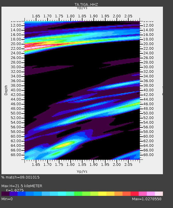
| Estimated Moho Depth: |
21.5 km |
| Estimated Crust Vp/Vs: |
1.63 |
| Assumed Crust Vp: |
6.565 km/s |
| Estimated Crust Vs: |
4.033 km/s |
| Estimated Crust Poisson's Ratio: |
0.20 |
|
| Radial Match: |
89.001015 % |
| Radial Bump: |
289 |
| Transverse Match: |
69.43952 % |
| Transverse Bump: |
329 |
| SOD ConfigId: |
13570011 |
| Insert Time: |
2019-04-30 05:05:20.360 +0000 |
| GWidth: |
2.5 |
| Max Bumps: |
400 |
| Tol: |
0.001 |
|

Signal To Noise
| Channel | StoN | STA | LTA |
| TA:TIGA: :HHZ:20180504T22:43:02.340027Z | 3.244036 | 1.0050766E-6 | 3.0982287E-7 |
| TA:TIGA: :HHN:20180504T22:43:02.340027Z | 1.0762732 | 2.6483968E-7 | 2.4607104E-7 |
| TA:TIGA: :HHE:20180504T22:43:02.340027Z | 1.3390256 | 4.3301154E-7 | 3.2337806E-7 |
| Arrivals |
| Ps | 2.2 SECOND |
| PpPs | 8.2 SECOND |
| PsPs/PpSs | 10 SECOND |


