You are here: Home > Network List > TA - USArray Transportable Network (new EarthScope stations) Stations List
> Station TUL3 Leonard, OK, USA > Earthquake Result Viewer
TUL3 Leonard, OK, USA - Earthquake Result Viewer
| Earthquake location: |
Hawaii |
| Earthquake latitude/longitude: |
19.4/-155.0 |
| Earthquake time(UTC): |
2018/05/04 (124) 22:32:55 GMT |
| Earthquake Depth: |
5.0 km |
| Earthquake Magnitude: |
5.8 Ml |
| Earthquake Catalog/Contributor: |
NEIC PDE/us |
|
| Network: |
TA USArray Transportable Network (new EarthScope stations) |
| Station: |
TUL3 Leonard, OK, USA |
| Lat/Lon: |
35.91 N/95.79 W |
| Elevation: |
265 m |
|
| Distance: |
54.2 deg |
| Az: |
59.288 deg |
| Baz: |
268.99 deg |
| Ray Param: |
0.06558754 |
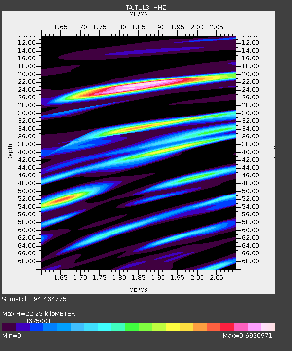
| Estimated Moho Depth: |
22.25 km |
| Estimated Crust Vp/Vs: |
1.87 |
| Assumed Crust Vp: |
6.498 km/s |
| Estimated Crust Vs: |
3.479 km/s |
| Estimated Crust Poisson's Ratio: |
0.30 |
|
| Radial Match: |
94.464775 % |
| Radial Bump: |
400 |
| Transverse Match: |
72.898 % |
| Transverse Bump: |
400 |
| SOD ConfigId: |
13570011 |
| Insert Time: |
2019-04-30 05:05:21.513 +0000 |
| GWidth: |
2.5 |
| Max Bumps: |
400 |
| Tol: |
0.001 |
|
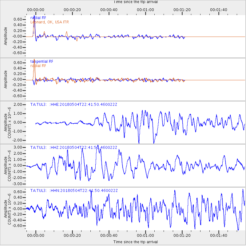
Signal To Noise
| Channel | StoN | STA | LTA |
| TA:TUL3: :HHZ:20180504T22:41:50.460022Z | 2.912279 | 3.1455187E-7 | 1.0800884E-7 |
| TA:TUL3: :HHN:20180504T22:41:50.460022Z | 1.2699597 | 1.371374E-7 | 1.07985635E-7 |
| TA:TUL3: :HHE:20180504T22:41:50.460022Z | 3.5204651 | 3.360632E-7 | 9.545988E-8 |
| Arrivals |
| Ps | 3.1 SECOND |
| PpPs | 9.3 SECOND |
| PsPs/PpSs | 12 SECOND |


