You are here: Home > Network List > UW - Pacific Northwest Regional Seismic Network Stations List
> Station DOSE Dosewallips old TA.C04A, WA > Earthquake Result Viewer
DOSE Dosewallips old TA.C04A, WA - Earthquake Result Viewer
| Earthquake location: |
Hawaii |
| Earthquake latitude/longitude: |
19.4/-155.0 |
| Earthquake time(UTC): |
2018/05/04 (124) 22:32:55 GMT |
| Earthquake Depth: |
5.0 km |
| Earthquake Magnitude: |
5.8 Ml |
| Earthquake Catalog/Contributor: |
NEIC PDE/us |
|
| Network: |
UW Pacific Northwest Regional Seismic Network |
| Station: |
DOSE Dosewallips old TA.C04A, WA |
| Lat/Lon: |
47.72 N/122.97 W |
| Elevation: |
53 m |
|
| Distance: |
38.4 deg |
| Az: |
35.224 deg |
| Baz: |
233.745 deg |
| Ray Param: |
0.07558376 |
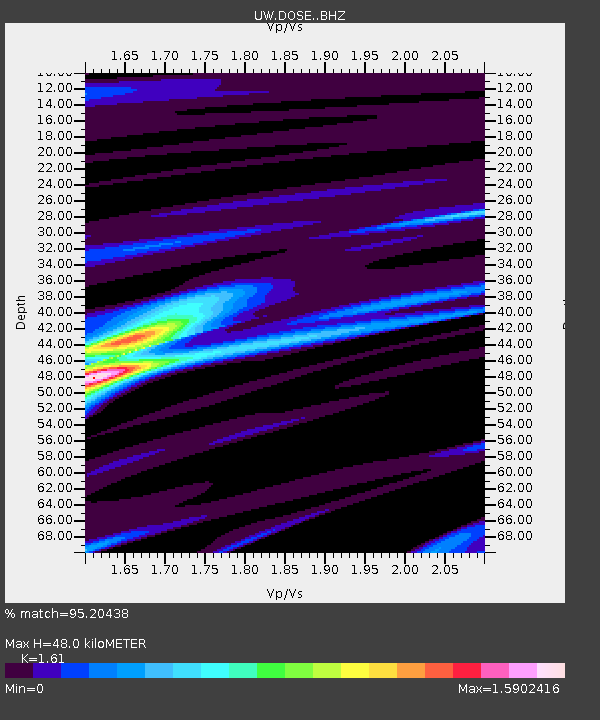
| Estimated Moho Depth: |
48.0 km |
| Estimated Crust Vp/Vs: |
1.61 |
| Assumed Crust Vp: |
6.566 km/s |
| Estimated Crust Vs: |
4.078 km/s |
| Estimated Crust Poisson's Ratio: |
0.19 |
|
| Radial Match: |
95.20438 % |
| Radial Bump: |
268 |
| Transverse Match: |
93.41655 % |
| Transverse Bump: |
339 |
| SOD ConfigId: |
13570011 |
| Insert Time: |
2019-04-30 05:06:09.054 +0000 |
| GWidth: |
2.5 |
| Max Bumps: |
400 |
| Tol: |
0.001 |
|

Signal To Noise
| Channel | StoN | STA | LTA |
| UW:DOSE: :BHZ:20180504T22:39:46.640015Z | 4.3976383 | 4.670169E-7 | 1.06197206E-7 |
| UW:DOSE: :BHN:20180504T22:39:46.640015Z | 1.8904217 | 2.6642758E-7 | 1.4093553E-7 |
| UW:DOSE: :BHE:20180504T22:39:46.640015Z | 1.0340443 | 1.3942157E-7 | 1.3483134E-7 |
| Arrivals |
| Ps | 4.8 SECOND |
| PpPs | 18 SECOND |
| PsPs/PpSs | 22 SECOND |


