You are here: Home > Network List > UW - Pacific Northwest Regional Seismic Network Stations List
> Station LCCR Mulino, OR, USA > Earthquake Result Viewer
LCCR Mulino, OR, USA - Earthquake Result Viewer
| Earthquake location: |
Hawaii |
| Earthquake latitude/longitude: |
19.4/-155.0 |
| Earthquake time(UTC): |
2018/05/04 (124) 22:32:55 GMT |
| Earthquake Depth: |
5.0 km |
| Earthquake Magnitude: |
5.8 Ml |
| Earthquake Catalog/Contributor: |
NEIC PDE/us |
|
| Network: |
UW Pacific Northwest Regional Seismic Network |
| Station: |
LCCR Mulino, OR, USA |
| Lat/Lon: |
45.21 N/122.48 W |
| Elevation: |
273 m |
|
| Distance: |
37.3 deg |
| Az: |
38.909 deg |
| Baz: |
237.012 deg |
| Ray Param: |
0.07623677 |
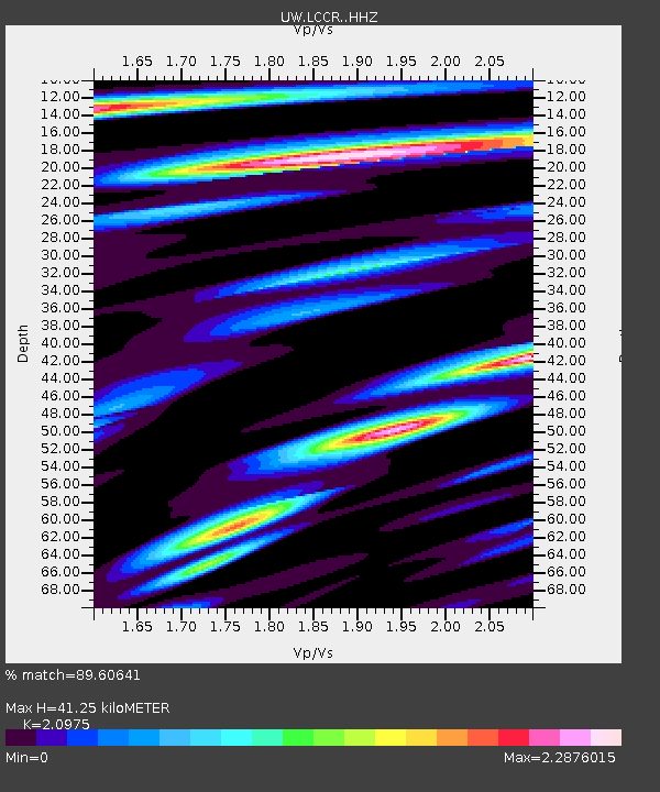
| Estimated Moho Depth: |
41.25 km |
| Estimated Crust Vp/Vs: |
2.10 |
| Assumed Crust Vp: |
6.566 km/s |
| Estimated Crust Vs: |
3.13 km/s |
| Estimated Crust Poisson's Ratio: |
0.35 |
|
| Radial Match: |
89.60641 % |
| Radial Bump: |
400 |
| Transverse Match: |
59.036636 % |
| Transverse Bump: |
400 |
| SOD ConfigId: |
13570011 |
| Insert Time: |
2019-04-30 05:06:14.175 +0000 |
| GWidth: |
2.5 |
| Max Bumps: |
400 |
| Tol: |
0.001 |
|

Signal To Noise
| Channel | StoN | STA | LTA |
| UW:LCCR: :HHZ:20180504T22:39:36.917999Z | 3.2124946 | 6.4199446E-7 | 1.9984297E-7 |
| UW:LCCR: :HHN:20180504T22:39:36.917999Z | 0.8857709 | 2.4718562E-7 | 2.790627E-7 |
| UW:LCCR: :HHE:20180504T22:39:36.917999Z | 2.6245043 | 6.296153E-7 | 2.3989872E-7 |
| Arrivals |
| Ps | 7.4 SECOND |
| PpPs | 18 SECOND |
| PsPs/PpSs | 26 SECOND |


