You are here: Home > Network List > XV14 - Fault Locations and Alaska Tectonics from Seismicity Stations List
> Station F6TP Tanana River 6, Topo, AK, USA > Earthquake Result Viewer
F6TP Tanana River 6, Topo, AK, USA - Earthquake Result Viewer
| Earthquake location: |
Hawaii |
| Earthquake latitude/longitude: |
19.4/-155.0 |
| Earthquake time(UTC): |
2018/05/04 (124) 22:32:55 GMT |
| Earthquake Depth: |
5.0 km |
| Earthquake Magnitude: |
5.8 Ml |
| Earthquake Catalog/Contributor: |
NEIC PDE/us |
|
| Network: |
XV Fault Locations and Alaska Tectonics from Seismicity |
| Station: |
F6TP Tanana River 6, Topo, AK, USA |
| Lat/Lon: |
64.87 N/149.56 W |
| Elevation: |
120 m |
|
| Distance: |
45.6 deg |
| Az: |
3.266 deg |
| Baz: |
187.237 deg |
| Ray Param: |
0.07117207 |
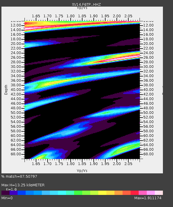
| Estimated Moho Depth: |
13.25 km |
| Estimated Crust Vp/Vs: |
1.60 |
| Assumed Crust Vp: |
6.566 km/s |
| Estimated Crust Vs: |
4.104 km/s |
| Estimated Crust Poisson's Ratio: |
0.18 |
|
| Radial Match: |
87.50797 % |
| Radial Bump: |
400 |
| Transverse Match: |
78.46975 % |
| Transverse Bump: |
400 |
| SOD ConfigId: |
13570011 |
| Insert Time: |
2019-04-30 05:06:38.724 +0000 |
| GWidth: |
2.5 |
| Max Bumps: |
400 |
| Tol: |
0.001 |
|

Signal To Noise
| Channel | StoN | STA | LTA |
| XV:F6TP: :HHZ:20180504T22:40:45.519989Z | 5.7217436 | 1.7642747E-6 | 3.0834562E-7 |
| XV:F6TP: :HHN:20180504T22:40:45.519989Z | 2.6892972 | 1.6976963E-6 | 6.312788E-7 |
| XV:F6TP: :HHE:20180504T22:40:45.519989Z | 0.5418794 | 5.957708E-7 | 1.0994527E-6 |
| Arrivals |
| Ps | 1.3 SECOND |
| PpPs | 4.9 SECOND |
| PsPs/PpSs | 6.2 SECOND |


