You are here: Home > Network List > US - United States National Seismic Network Stations List
> Station NATX Nacogdoches, Texas, USA > Earthquake Result Viewer
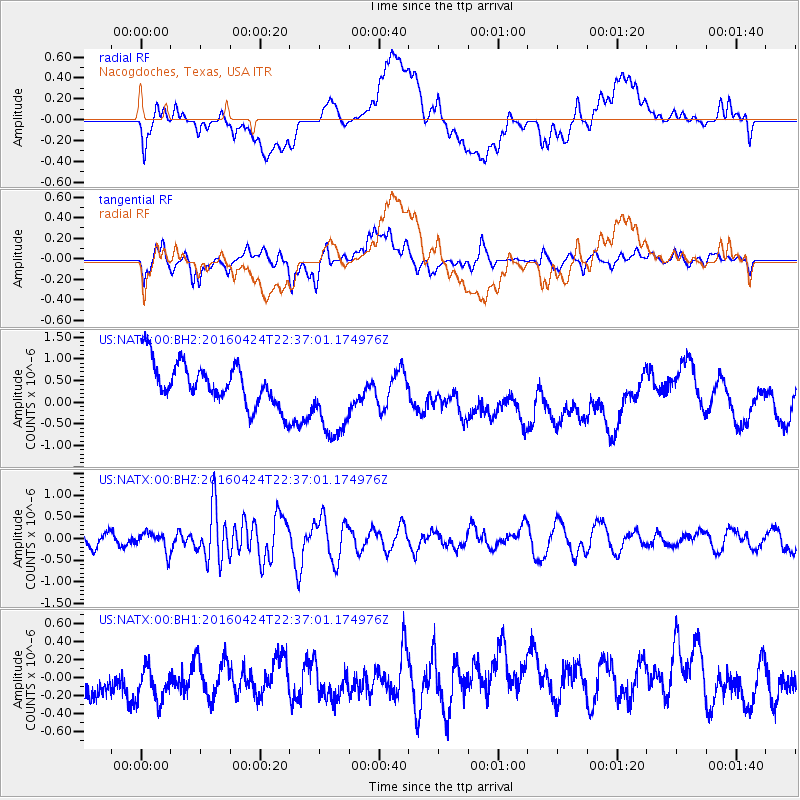
NATX Nacogdoches, Texas, USA - Earthquake Result Viewer
*The percent match for this event was below the threshold and hence no stack was calculated.
| Earthquake location: |
Tonga Islands |
| Earthquake latitude/longitude: |
-17.7/-173.2 |
| Earthquake time(UTC): |
2016/04/24 (115) 22:24:36 GMT |
| Earthquake Depth: |
27 km |
| Earthquake Magnitude: |
5.7 MWW, 5.6 MWB, 5.7 MWC |
| Earthquake Catalog/Contributor: |
NEIC PDE/NEIC COMCAT |
|
| Network: |
US United States National Seismic Network |
| Station: |
NATX Nacogdoches, Texas, USA |
| Lat/Lon: |
31.76 N/94.66 W |
| Elevation: |
168 m |
|
| Distance: |
89.8 deg |
| Az: |
56.602 deg |
| Baz: |
249.11 deg |
| Ray Param: |
$rayparam |
*The percent match for this event was below the threshold and hence was not used in the summary stack. |
|
| Radial Match: |
26.345053 % |
| Radial Bump: |
400 |
| Transverse Match: |
61.91469 % |
| Transverse Bump: |
400 |
| SOD ConfigId: |
1475611 |
| Insert Time: |
2016-05-31 23:04:28.502 +0000 |
| GWidth: |
2.5 |
| Max Bumps: |
400 |
| Tol: |
0.001 |
|
Signal To Noise
| Channel | StoN | STA | LTA |
| US:NATX:00:BHZ:20160424T22:37:01.174976Z | 1.5352862 | 2.1970206E-7 | 1.431017E-7 |
| US:NATX:00:BH1:20160424T22:37:01.174976Z | 1.0688535 | 2.8884946E-7 | 2.7024237E-7 |
| US:NATX:00:BH2:20160424T22:37:01.174976Z | 2.008631 | 9.806563E-7 | 4.8822125E-7 |
| Arrivals |
| Ps | |
| PpPs | |
| PsPs/PpSs | |


