You are here: Home > Network List > TA - USArray Transportable Network (new EarthScope stations) Stations List
> Station K22A Casper, WY, USA > Earthquake Result Viewer
K22A Casper, WY, USA - Earthquake Result Viewer
| Earthquake location: |
Kermadec Islands Region |
| Earthquake latitude/longitude: |
-27.4/-176.3 |
| Earthquake time(UTC): |
2009/02/18 (049) 21:53:45 GMT |
| Earthquake Depth: |
25 km |
| Earthquake Magnitude: |
6.8 MB, 7.2 MS, 6.9 MW, 6.9 MW |
| Earthquake Catalog/Contributor: |
WHDF/NEIC |
|
| Network: |
TA USArray Transportable Network (new EarthScope stations) |
| Station: |
K22A Casper, WY, USA |
| Lat/Lon: |
42.65 N/106.52 W |
| Elevation: |
1686 m |
|
| Distance: |
94.8 deg |
| Az: |
44.011 deg |
| Baz: |
236.837 deg |
| Ray Param: |
0.04095453 |
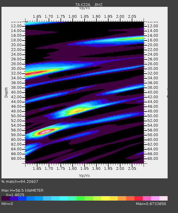
| Estimated Moho Depth: |
56.5 km |
| Estimated Crust Vp/Vs: |
1.68 |
| Assumed Crust Vp: |
6.178 km/s |
| Estimated Crust Vs: |
3.672 km/s |
| Estimated Crust Poisson's Ratio: |
0.23 |
|
| Radial Match: |
94.20607 % |
| Radial Bump: |
352 |
| Transverse Match: |
89.70099 % |
| Transverse Bump: |
400 |
| SOD ConfigId: |
2658 |
| Insert Time: |
2010-03-06 10:57:29.435 +0000 |
| GWidth: |
2.5 |
| Max Bumps: |
400 |
| Tol: |
0.001 |
|

Signal To Noise
| Channel | StoN | STA | LTA |
| TA:K22A: :BHZ:20090218T22:06:32.800015Z | 4.7673054 | 1.2716774E-6 | 2.6674974E-7 |
| TA:K22A: :BHN:20090218T22:06:32.800015Z | 1.3169612 | 2.5365145E-7 | 1.9260358E-7 |
| TA:K22A: :BHE:20090218T22:06:32.800015Z | 2.2275884 | 4.634842E-7 | 2.0806547E-7 |
| Arrivals |
| Ps | 6.4 SECOND |
| PpPs | 24 SECOND |
| PsPs/PpSs | 30 SECOND |


